
River Clyde, Rowantree Pool


Bridge (19th Century)
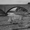
Site Name River Clyde, Rowantree Pool
Classification Bridge (19th Century)
Alternative Name(s) River Clyde
Canmore ID 345942
Site Number NS91NE 91
NGR NS 95745 18314
Datum OSGB36 - NGR
Permalink http://canmore.org.uk/site/345942


- Council South Lanarkshire
- Parish Crawford
- Former Region Strathclyde
- Former District Clydesdale
- Former County Lanarkshire
Field Visit (12 November 2014)
Very little is now visible of this road bridge which is depicted crossing the River Clyde immediately SE of Rowantree Pool on the 1st edition of the OS 25-inch map (Lanark 1864, Sheet XLVII (Crawford)). The abutment on the NW bank of the river measures 4m in breadth by 0.3m in height in which two courses of stonework are visible and it is approached from the NW by a ramp 15m in length and up to 0.2m in height. Less well preserved traces of the bridge can also be seen on the SE bank of the river.
Visited by RCAHMS (AM) 12 November 2014.

