
Craigmill


Barrow Cemetery (Prehistoric), Pit(S) (Period Unknown), Rig And Furrow (Medieval) - (Post Medieval), Ring Ditch(S) (Prehistoric)
Site Name Craigmill
Classification Barrow Cemetery (Prehistoric), Pit(S) (Period Unknown), Rig And Furrow (Medieval) - (Post Medieval), Ring Ditch(S) (Prehistoric)
Canmore ID 34516
Site Number NO53NE 35
NGR NO 578 362
Datum OSGB36 - NGR
Permalink http://canmore.org.uk/site/34516


- Council Angus
- Parish Panbride
- Former Region Tayside
- Former District Angus
- Former County Angus
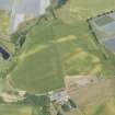
NO53NE 35 578 362 to 580 359.
Aerial Photographic Transcription (28 July 2017)
An interpretative transcription, or mapping, of information on oblique aerial photographs was produced on 28 July 2017.

