
Craigmill


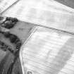
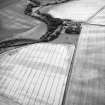
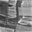
Enclosure (Period Unknown), Rig And Furrow (Medieval) - (Post Medieval)
Site Name Craigmill
Classification Enclosure (Period Unknown), Rig And Furrow (Medieval) - (Post Medieval)
Canmore ID 34509
Site Number NO53NE 29
NGR NO 57915 35996
Datum OSGB36 - NGR
Permalink http://canmore.org.uk/site/34509


- Council Angus
- Parish Panbride
- Former Region Tayside
- Former District Angus
- Former County Angus
Aerial Photographic Transcription (28 July 2017)
An interpretative transcription, or mapping, of information on oblique aerial photographs was produced on 28 July 2017.

