
Pricing Change
New pricing for orders of material from this site will come into place shortly. Charges for supply of digital images, digitisation on demand, prints and licensing will be altered.
Delvine, Golf Course


Golf Course (20th Century)
Site Name Delvine, Golf Course
Classification Golf Course (20th Century)
Alternative Name(s) Inchtuthil
Canmore ID 345045
Site Number NO13NW 81
NGR NO 12540 39788
NGR Description Centred on NO 12540 39788
Datum OSGB36 - NGR
Permalink http://canmore.org.uk/site/345045


- Council Perth And Kinross
- Parish Caputh
- Former Region Tayside
- Former District Perth And Kinross
- Former County Perthshire
Note (8 September 2014)
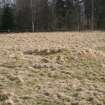
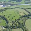
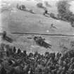
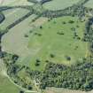
At Delvine House policies, just over 2 miles to the north west of Ballathie House, is one of the few relict golf courses in Perthshire where there are upstanding remains due to the course being located over the protected archaeological site of Inchtuthil Roman Fort. A ditch of the Roman Fort dissects the picture with small semi-circular bunkers scattered throughout and a green on the right by the trees.
The course occupied most of the parkland to the southeast of the house and was enclosed by a tree plantation. It was most likely commissioned by Hugh Hogarth who acquired Delvine Estate in 1921. The first mention of a golf course on a Perth valuation rolls is the 1930-1931 roll and the last on the 1946-1947 roll. This short lived golf course was enjoyed by many as mentioned in Hugh Hogarth’s obituary (7/7/1954) and it also records that the land was turned over to agricultural use during the Second World War. (Source: John Watson, Work Experience Student, Perth and Kinross Council Archive).
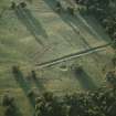
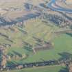
The course must have been restored immediately after the war as it is shown on an aerial photograph taken in 1946. Some of the holes can be worked out although the complete layout of the course is unclear. A small circular starter’s box with an adjacent tee ground is visible just south of the site of Delvine House. This building would be similar in style to the home of Bruntsfield Short Hole Golf Course, Edinburgh. This tee must have been for the first hole which followed the line of the trees on the east to a well bunkered green located beside an avenue hown on the Royal Military Survey of Scotland map, an 18th century map of the entire Scottish mainland. The teeing ground on the west appears to have been used for the final hole, a well bunkered hole which goes north towards the starter’s box. This teeing ground may also have been used for a long hole which goes east to a green protected by three bunkers and the ditch of the Roman fort. Just south of this green are two teeing grounds, one for a short hole going west with the green located by a small clump of trees. The rest of the layout is unclear. However it is possible to surmise that a further hole went south west to a bunkered green from a tee on the east. Perhaps a teeing ground is located next to this green as there is a possible short hole leading north east. There may also have been a dog-leg hole on the west.
On the ground most of the golf course features shown on the aerial image are easily identifiable. Bunkers survive as grassed over semi-circular raised mounds, tees as small raised platforms although the definition of some of the greens have been lost in the grassland. The prominent remains of the bunkers hint at a quality course where money, time and effort were spent in its construction and upkeep.
Information from RCAHMS (RC) 1 June 2014.

