
Scryne Smithy


Enclosure (Period Unassigned)(Possible), Rig And Furrow (Medieval), Temporary Camp (Roman)(Possible)
Site Name Scryne Smithy
Classification Enclosure (Period Unassigned)(Possible), Rig And Furrow (Medieval), Temporary Camp (Roman)(Possible)
Canmore ID 34493
Site Number NO53NE 14
NGR NO 588 366
Datum OSGB36 - NGR
Permalink http://canmore.org.uk/site/34493


- Council Angus
- Parish Panbride
- Former Region Tayside
- Former District Angus
- Former County Angus
Publication Account (17 December 2011)
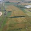
A rounded corner and stretches of two adjacent sides, which may be part of a Roman camp, are visible some 700m from the harbour at East Haven. Recorded from the air in 1983 by Maxwell (1990a: 122), some 95m of the ESE side are known together with 45m of the NNE. The cropmarks are blurred by a morass of linear markings (drainage ditches and rig), and the area is littered with cropmark remains from the prehistoric to the medieval and modern periods.
R H Jones.

