
Pricing Change
New pricing for orders of material from this site will come into place shortly. Charges for supply of digital images, digitisation on demand, prints and licensing will be altered.
Newark Castle


Castle (Medieval)
Site Name Newark Castle
Classification Castle (Medieval)
Alternative Name(s) St Monance Castle; St Monans
Canmore ID 34203
Site Number NO50SW 17
NGR NO 51824 01191
Datum OSGB36 - NGR
Permalink http://canmore.org.uk/site/34203


- Council Fife
- Parish St Monance
- Former Region Fife
- Former District North East Fife
- Former County Fife
NO50SW 17.00 51824 01191
(NO 5182 0120) Newark Castle (NR)
(In Ruins)
OS 6" map (1938)
NO50SW 17.01 NO 5165 0125 Harness-trappings
NO50SW 17.02 NO 5182 0120 Geophysical Survey
NO50SW 17.03 NO 51925 01214 Dovecot
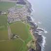
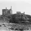
The remains of Newark Castle stand on a small promontory running into the sea. The main buildings stand on the summit of the promontory to the E with remains of an enclosing wall to the S and on the W along the cliff.
The earliest work is in the three most southerly vaulted cellars of the E range. These have been altered and give no indication of date. In the second period, early 16th century, the block was extended N and terminated at the NE angle in a circular tower, with an entrance gate facing N in its W side. In the third period, late 16th century, a new house was built on the second period ground floor, extending from the cellars to the wall of the tower and having a stair tower towards the courtyard. Late in the 16th century, the cellarage was altered and buildings at the S end of the courtyard, as well as those on the lower level, erected. In the fourth period, later 17th century, a storey was added to the 16th c house, and an upper storey to the tower. The courtyard was divided by a cross wall running N along the W cliff to meet the main outer wall.
Other buildings, now represented by fragments of vaulted cellars, lay at a lower level towards the NW, access between the two parts being maintained by a newel stair, still traceable. At the lower level there was probably a water gate.
RCAHMS 1933, visited 1927
Generally as described and planned, although the N tower has partially collapsed and the walling on the W has been eroded by the sea.
Visited by OS (DWR), 30 May 1974.
NO 518 012. Newark Castle sits on a promontory on the N side of the Firth of Forth, 1km W of St Monans. It probably dates from the 15th century and originally comprised ranges of buildings set around a courtyard. In the 16th century, the E range was extended northwards and a circular tower built onto it. Later that century, the upper parts of the N end of the E range and the tower were rebuilt and some of the ground-floor chambers altered, the northernmost one becoming a kitchen. In the late 17th century, the 16th-century house was heightened and Dutch gables added to it. Some parts of the castle were still occupied well into the 19th century when the tower walls were cut back to provide additional living space. This action contributed to the collapse of the N wall of the tower early in the 20th century, whilst coastal erosion has resulted in the loss of other buildings, including the entire W side of the castle.
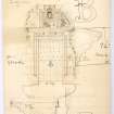
An archaeological evaluation was undertaken in advance of a proposed programme of restoration of the N end of the E range and its round tower. The principal areas of excavation were: the interior of the round tower and its entrance passage; the kitchen and its fireplace; the first-floor hall; and four trenches against the castle walls.
The tower. The remains of the tower stood five storeys above ground level, although excavation also uncovered a hitherto unsuspected basement. The tower measured 7.5m in diameter over walls 2.2m thick at their base, but reduced over most of the building's height. Piercing the E and W walls of the basement were embrasures terminating in circular gun-loops which had probably opened onto a ditch. At some stage the ditch had been backfilled with at least 5m of rubble and soil. The basement floor was bedrock, into which a square feature had been cut - perhaps a well - which was not excavated. From ground level upwards, the tower walls have been reduced and alterations made to many of the mural features, such as windows and gun-loops.
The kitchen. The kitchen was formed when a large fireplace was inserted into the end of the northernmost undercroft of the E range. Most of the floor of this chamber comprised bedrock although some crude paving had been added where there were undulations in the rock. Cutting the bedrock was a narrow channel leading to a slop drain, set below a window in the E wall.
First-floor hall. This room, probably a hall during the later phases of occupation, lay directly over the kitchen and measured 6.2m N-S by 5m wide internally. Turf and debris overlay a deposit of sand, presumably the setting for floor tiles or flags, although no trace of either remained. There were two fireplaces in the hall, one directly over the kitchen fireplace, and another much smaller one in the S wall.
Trenches outside the castle. Four trenches were excavated against the castle walls, primarily to determine the depths of their foundations. This objective proved difficult to achieve for several reasons, although some interesting features were nevertheless uncovered. Trenches were opened against the two main doorways into the E range, one of which gave access to the passage leading to the tower, the other to the kitchen and a turnpike stair (now demolished) which led to the first-floor hall. In both trenches, large sandstone flags were overlain by a secondary surface of hard-packed gravel. In a trench outside the E range a relieving arch was uncovered near the base of the E wall, over 2m below present ground level. Also in this trench were the only artefacts pre-dating the late 19th century - sherds of probable 17th-century pottery, some of it French.
Sponsor: Nola Crewe.
J Lewis 2002.
Field Visit (22 July 1927)
Newark Castle.
Almost half a mile to the south-west of St. Monans a small promontory runs out into the sea. Its western side, which is actually overhanging, stands some 30 feet above the shore, though dipping at one place to about half that height. The main buildings of the castle stand on the summit of the promontory and are set on the eastern side and across the southern end, while on the west is a cliff on which are remnants of walling, the whole enclosing a small courtyard. Other buildings, now represented merely by fragments of vaulted cellars, lay at a lower level towards the north-west, access between the two parts being maintained by a newel-stair, still traceable. At the lower level there was probably a water-gate. The upper buildings, less fragmentary but entirely ruinous, show four main periods of construction. The earliest work is to be found in the three most southerly of the vaulted cellars in the eastern range. These have undergone a certain amount of alteration and afford no definite indication of date. In the second period, about the early 16th century, the block was extended northward and terminated at the north-east angle in a circular tower, with an entrance gate, facing north, in its western side. Only on the ground floor, however, is it possible to identify any work of this period apart from the tower, since in the third period, which can be tentatively described as the later 16th century, a new house, extending northward from the southern cellars to the wall of the tower and having a stair-tower towards the courtyard, was built on the old second-period ground floor. Late in the 16th century the cellarage was altered, while it is apparently to this later period that the buildings at the southern end of the courtyard, as well as those on the lower level, ought to be assigned. In the fourth period, which can be set down as the later 17th century, a storey was added to the16th-century house, and the voids, wall-head, and gables were embellished with contemporary moulded work. An upper storey was also added to the tower, and the courtyard was divided by a cross wall which runs northward along the western cliff to meet the main outer wall.
The entrance has been in the screen wall set astride the neck of the promontory on the north. A horizontal gun-loop exists in the surviving east side and there are similar gun-loops spread over the three lower floors of the round tower, which is five storeys in height. The 17th-century top storey is offset and has a moulded eaves-course. The 16th-century house immediately behind the tower was originally three storeys high, and the 17th-century heightening is clearly indicated on the north gable, which was then given its present curvilinear finish. The ground floor was the kitchen, a vaulted chamber with a fine arched fireplace in the north gable lit by two side windows. An arched recess in the west wall may have been for a bucket. The original entrance to this room is obscured by a 17th-century doorpiece at the foot of a turnpike, which gave access to the floors above. These upper floors are now fragmentary, but they contain evidence of late 17th-century alterations.
DOVECOT. - A circular dovecot of the 16th century stands on the cliff 100 yards east of the castle. It measures 14 ½ feet in diameter within walls 3 feet 8 inches in thickness. There have been one string-course and one offset course. The nests have been partly removed. The stone roof is apparently of later date.
HISTORICAL NOTE. - During the 16th century these lands belonged to the Sandilands of Cruivie (cf. No. 407), having been acquired, along with Cruivie, by the marriage of a Sandilands of Calder with the heiress of their predecessors, the Kinlochs. In 1545 the superior, the Prior of Pittenweem, granted to James Sandilands of Cruivie "certain acres belonging to our manor, commonly called the Newark of St. Monans” (1). The name was apparently derived from the "new-wark" or new building of the castle in its second period, as defined in the description. In 1645 Sir James Sandilands of St. Monans, afterwards Lord Abercrombie, was served heir to his grandfather in these lands "with the' tower and fortalice of St. Monance called the New-wark" (2). Four years later the property was purchased by General Sir David Leslie (3), who in 1661 was created Lord Newark and died in 1682
RCAHMS 1933, visited 22 July 1927
(1) Wood's East Neuk of Fife, p. 234. (2) Inquis. Spec., Fife, No. 693. (3) Diary of John Lamont of Newton (Maitland Club), p. 11.
Aerial Photography (21 January 2022)
HES Archaeological Survey undertook an aerial photographic survey of Newark Castle on 21 January 2022 in response to a request from colleagues in the Planning, Consents and Advice team. The survey consisted of the capture of 48 oblique aerial photographs from a DJI Phantom 4 Pro UAV and 22 from a DJI Inspire 2 UAV with a Zenmuse X7 camera, archived in both raw (DNG) and tiff format.
Visited by HES Survey and Recording (GFG) 21 January 2022.

