
Pricing Change
New pricing for orders of material from this site will come into place shortly. Charges for supply of digital images, digitisation on demand, prints and licensing will be altered.
Upcoming Maintenance
Please be advised that this website will undergo scheduled maintenance on the following dates:
Thursday, 9 January: 11:00 AM - 3:00 PM
Thursday, 23 January: 11:00 AM - 3:00 PM
Thursday, 30 January: 11:00 AM - 3:00 PM
During these times, some functionality such as image purchasing may be temporarily unavailable. We apologise for any inconvenience this may cause.
Sanday, Elsness


Barrow(S) (Prehistoric), Cairn(S) (Prehistoric), Enclosure (Prehistoric)
Site Name Sanday, Elsness
Classification Barrow(S) (Prehistoric), Cairn(S) (Prehistoric), Enclosure (Prehistoric)
Alternative Name(s) Sivers Geo
Canmore ID 3410
Site Number HY63NE 6
NGR HY 67312 37554
Datum OSGB36 - NGR
Permalink http://canmore.org.uk/site/3410


- Council Orkney Islands
- Parish Lady
- Former Region Orkney Islands Area
- Former District Orkney
- Former County Orkney
HY63NE 6 c. 673 375.
See also HY63NE 5 and HY63NE 13.
(Area: HY 673 375 Tumuli (NR)
(HY 6736 3740) Tumulus(NR)
OS 6"map, Orkney, 2nd ed.,(1900).
More than twenty small mounds with faint traces of others which have been destroyed by cultivation. The survivors seem to have been connected by a rudely built wall or setting of stones, but this feature is not continuously traceable.
The diameters of the mounds range from about 18' to 36' but none is more than 2' high. They are composed largely of stones now so overgrown that details are obscured, but it is noticeable that on each there is distinct evidence of 'cramp'.
Cists are said to have been exposed in some of them and the discovery of a large stone arrow or spear-head about 3" long, as well as a bone axe, is also recorded. (New Statistical Account [NSA, Rev W Traill] 1845).
RCAHMS 1946, visited 1928 and 1935.
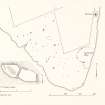
Scattered over a wide area of pasture are at least 26 turf-covered cairns, varying in size from c6.0m to 12.0m in diameter and 0.3m to 0.8m high, and in shape from circular to oval, with one being "mirror-shaped" (See 'A' on plan). Stones can be seen protruding through the turf.
These cairns are similar in size and shape to the group of eleven, 100.0m to the E (HY63NE 5), but there is no trace of the "rudely built wall" connecting them mentioned by the RCAHMS, although the tops of one or two isolated upright slabs are visible. There have almost certainly been several other mounds, now surviving as faint swellings too amorphous to identify positively.
Some 300.0m to the SE by the shore at HY 6753 3728, is a turf-covered stony bank containing numerous upright slabs, which with the shoreline forms an enclosure, c40.0m by c20.0m.
Its date or purpose cannot be ascertained.
Surveyed at 1/2500
Visited by OS(NKB) 7 July 1970.
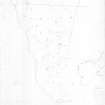
HY 676 375 (centre) EDM survey was undertaken at this site near Quoyness in September 1996. The site comprises a large field of 18 mounds (including NMRS HY63NE 3, HY63NE 5, HY63NE 6 ), and a chain of 11 mounds linked by a dyke which surround the probable chambered cairn at Egmondshowe. Since the survey was undertaken, the Scheduled area has been enlarged to take in the chain of mounds.
A survey report has been lodged with the NMRS.
Sponsor: Historic Scotland
J Downes 1998
Orkney Smr Note (June 1979)
'Elsness appears to have been an extensive settlement ... From Augmund's Howe there may be traced the remains of a wall thickly studded with circular forts, running to the north-west across the Ness, and thus enclosing fully a third of the whole Ness. These small forts on the wall are, now, only runious cairns. They are all, or most of them, placed on the inside of the wall. The enclosed space is literally covered with tumuli
and heaps of ruins. The largest have been levelled and ploughed over ... Most of these tumuli which have been opened, contained burned stones, ashes, bones and sea shells. In some of them, were graves lined with flat stones. An axe, said to be of bone, was found some years ago, but was destroyed by the ignorant people who found it. An arrow - or spear-head was also found at the same time. It is of stone, three inches long, and
lozenge-shaped. The point is broken off. Many such articles might have been discovered, had proper persons superintended the removal of the tumuli. A number of the smaller heaps within the walls are formed of what the country people call cramp, and are said to have been used as places of sacrifice. For whatever purpose they were used, it is plain they must have been the sites of strong and long-continued fires. The cramp resembles the refuse from a glass-blower's furnace. It is of a reddish colour, and contains portions of a coarse glass, stones, and sometimes fragments of earthen vessels. The sea-weed, with which the shores abound, must have furnished the fuel. This, by long heat, would be reduced to kelp, and, by a continuance of the heat, and the admixture of sand and stones, would, in process of the time, produce the cramp ... Throughout the Ness, there are several circles of stones, with, for the most part, a central stone also set on edge. None of these stones are more than two feet above ground, and perhaps about as much under. All the circles
measured nearly the same in circumference, about 36 feet. None of them are to be found above a few yards from the beach. The finest specimens are at a creek ... called Kettletoft. On each side of this creek, are two circles; the first two are close by the beach, the other two at the upper extremity of the creek.
The only tumuli outside the line of forts are three or four, at a short distance from Augmund's Howe. All the rest, burghs, tumuli, and circles, are on the west side, that is, within the fortified wall.' Wood compares the Elsness structures with those on Toftness, remarking that the Toftness examples are better preserved because of the sandblow there; '...they both appear to be the work of the same race of people.' None of the Elness circles had been opened. [R1], OR 306.
Detailed ground survey by J Stevenson & A Leith, RCAMS,
August 1981. [R2]
More than 20 mounds visible on low ground near Silvers Geo, faint traces of others destroyed by cultivation. They seem to have been connected by a rude wall or setting of stones. 'Cramp' in each mound. Cists said to have been exposed in some of them. [R3]
In the Petrie transcription of Wood's original MS, where NSA has 'at creek ... called Kettletoft', is 'an excellent harbour called Sybers Geo'. Petrie manuscript SAS 551, in RMS.
Scattered over a wide area of pasture at least 26 turfed-over cairns, 6m-12m diameter, 0.3-0.8m high, circular or oval, one 'mirror-shaped'. Stones visible protruding through turf. Similar in size and shape to the group of eleven, 100m east, but no trace of the 'rudely built wall' connecting them mentioned by RCAMS, although the tops of one or two isolated upright slabs visible. There have almost certainly been other mounds represented by faint swellings.
OS visit Jul 70, OR 307.
As described by OS.
Information from Orkney SMR (RGL) Jun 79.
Note (1980)
Elsness, Sanday HY c. 673 375 HY63NE 6 & 13
At least twenty-six cairns scattered over a wide area. The New Statistical Account records burials, stone objects and 'cramp' in them.
RCAHMS 1980
(NSA, xv, Orkney, 136-8; RCAHMS 1946, ii, p. 170, Nos. 452,457; OR 309)
Note (1980)
Els Ness, Sanday HY 6753 3728 HY63NE 6
A bank containing many erect slabs and forming an enclosure 40m by 20m against the top of the shore-line
RCAHMS 1980
(OR 310)
Field Visit (30 August 1996)
Surveyed by JD Sept 1996 along with those mounds surrounding Egmonds Howe. This is an extraordinary, large group of barrows, the largest in Orkney comprising 26 barrows, also associated with the 11 barrows surrounding Egmonds Howe. Considering the level of survival of this field of barrows and its associations this site is of great importance. The barrows themselves are fairly large, and mostly made of earth.
Elsness 1: HY 67370 37780. Bowl-shaped with kerb. Diam 8.5mx8.5m. Height 0.4m. Stone slabs visible. Mound visible from W/NW/SW vis 3-400m
Elsness 2: HY 67370 37730. Bowl-shaped. Diam 7.5mx7.5m. Height 0.4m. Some slabs visible. Mound in prominent location on crest and visible from 500m+ to E/W
Elsness 5: HY 67310 37670. Bowl-shaped. Diam 7.5mx7.5m. Height 0.25m.Some stones are visible. Mound located on a flat area of ground and is not particularly prominent.
Elsness 6: HY 67290 37710. Bowl-shaped. Diam 5m by 5m. Height 0.2m. Not prominent.
Elsness 7: HY 67300 37700. Possibly bowl-shaped. Diam 10m by 10m. Height 0.05m. Not prominent.
Elsness 8: HY 67210 37660. Bowl-shaped. Diam 7.5m by 7.5m. Height 0.6m. Some stones visible. Mound is prominent in all directions 500m and to sea.
Elsness 9: HY 67210 37630. Bowl-shaped. Diam 9.0m by 6.0m. Height 0.25m. Visible from mounds 8 and 10.
Elsness 11: HY 67210 37600. Bowl-shaped. Diam 7.5m by 7.5m. Height 0.5m. Visible from mounds 8,9 and 10.
Elsness 14: HY 67350 37530. Bowl-shaped. Diam 7.5m by 7.5m. Height 0.35m. Located on sloping ground.
Elsness 15: HY 67330 37560. Bowl-shaped. Diam 7.5m by 7.5m. Height 0.35m. Located on sloping ground.
Elsness 16: HY 67380 37570. Bowl-shaped. Diam. 8m by 8m. Height 0.3m. Visible for 500m from land and sea.
Elsness 17: HY 67410 37570. Possibly bowl-shaped. Diam 9m by 9m. Height 0.2m. Some stone uprights visible. Not particularly prominent.
Elsness 20: HY 67340 37460. Cairn with a diam 7.5m by 7.m. Height 0.2m. Masonry courses visible. The cairn is visible from the sea and also from 200m north and south.
Elsness 21: HY 67390 37410. Bowl-shaped. Diam 10m by 10m. Height 0.3m. Visible from c. 200m in some directions.
Elsness 22: HY 67460 37360. Bowl-shaped. Diam 8.5m by 8.5m. Height 0.25m. Some stone uprights visible. Located in a slight basin.
Elsness 23: HY 67460 37420. Bowl-shaped. Diam 10m by 10m. Height 0.3m. Located on a spur on the promontory.
Elsness 24: HY 67380 37430. Bowl-shaped. Diam 10m by 12m. Height 0.3m. Visible for c. 200m to the south east.
Elsness 25: HY 67440 37490. Bowl-shaped. Diam 7.5m by 7.5m. Height 0.2m. Not prominent.
Elsness 28: HY 67570 37400. Bowl-shaped. Diam 8m by 8m. Height 0.2m. Located on the break of a gentle slope.
Field Visit (1999)
A grass-covered mound lies on the coast edge and is eroding. Oval in shape, it measures 10m by 5m and stands up to 0.5m high. Stone can be seen protruding from the centre of the mound and further stones are visible in rabbit scrapes on its southern flanks. The coastal section extends for 11m in front of the mound. In it is revealed a concentration of slabs, 0.7m high, which lie in a roughly horizontal fashion. This structure, which would appear to be a cairn, may be an additional element to the group of cairns previously recorded in this area (SY66: HY63NE6)
Coastal Zone Assessment Survey, 1999
Field Visit (1999)
Twenty-six or more cairns have been recorded in the field which lies at the southern tip of Els Ness. These are scattered widely over the area and are visible as small grassy rises, mostly under 12m in diameter and 0.5m in height. Recent survey work in this area found only eighteen mounds; the remainder are likely to have been reduced or removed through cultivation and animal poaching. The NSA records that cists were once visible in some of the mounds and several contained cramp and stone objects. Ref.: NSA (1845), Vol.15, 137; RCAHMS (1946) #452; RCAHMS (1980) #8; Downes, J (1998) 'Elsness, Sanday (Lady Parish)- survey of burial mounds' in DES 1998.
Coastal Zone Assessment Survey, 1999

