 |
On-line Digital Images |
SC 2407511 |
Records of the Ordnance Survey, Southampton, Hampshire, England |
Anstruther Wester, High Street, St Adrian's Church Hall, NO50SE 10, Ordnance Survey index card, Recto |
c. 1958 |
Item Level |
|
 |
On-line Digital Images |
SC 2407512 |
Records of the Ordnance Survey, Southampton, Hampshire, England |
Anstruther Wester, High Street, St Adrian's Church Hall, NO50SE 10, Ordnance Survey index card, Recto |
c. 1958 |
Item Level |
|
 |
On-line Digital Images |
SC 2407513 |
Records of the Ordnance Survey, Southampton, Hampshire, England |
Anstruther Wester, High Street, St Adrian's Church Hall, NO50SE 10, Ordnance Survey index card, Recto |
c. 1958 |
Item Level |
|
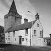 |
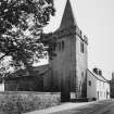
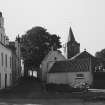
On-line Digital Images |
SC 2510931 |
|
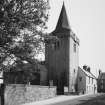
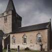
View from south west of Tolbooth and Church Tower |
8/5/1990 |
Item Level |
|
 |
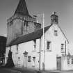
On-line Digital Images |
SC 2510932 |
|
View from north west of Church Tower and Tolbooth |
8/5/1990 |
Item Level |
|
 |
On-line Digital Images |
SC 2510977 |
|
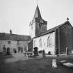
General view from east of Tolbooth Church and Churchyard |
8/5/1990 |
Item Level |
|
 |
On-line Digital Images |
SC 2510978 |
|
View from south west of Tower, Church hall and churchyard |
8/5/1990 |
Item Level |
|
 |
On-line Digital Images |
SC 2510979 |
|
View from south west of Tower, Church hall and churchyard |
8/5/1990 |
Item Level |
|
 |
On-line Digital Images |
SC 2510980 |
|
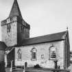
View from north west of Church Tower and Tolbooth |
8/5/1990 |
Item Level |
|
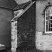 |
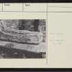
On-line Digital Images |
SC 2510983 |
|
Base of tower, view from west showing angle between Church and Town House |
8/5/1990 |
Item Level |
|
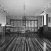 |
On-line Digital Images |
SC 2510984 |
|
Interior of St Adrian's Church Hall, view from west |
21/9/1994 |
Item Level |
|
 |
On-line Digital Images |
SC 2510985 |
|
Interior of St Adrian's Church Hall, view from west |
21/9/1994 |
Item Level |
|
 |
On-line Digital Images |
SC 2511036 |
|
View from south west of Tolbooth and Church Tower |
1977 |
Item Level |
|
 |
On-line Digital Images |
SC 2511037 |
|
View from east of The Esplanade and Parish Church and churchyard |
1977 |
Item Level |
|
|
All Other |
551 166/1/1 |
Records of the Ordnance Survey, Southampton, Hampshire, England |
Archaeological site card index ('495' cards) |
1947 |
Sub-Group Level |
|
|
All Other |
551 214/7/19 |
Records of Rathmell Archaeology Ltd, archaeologists, Kilbarchan, Renfrewshire, Scotland |
Archive for excavation at St Nicholas' Church, High Street, Anstruther Wester |
7/9/2016 |
Sub-Group Level |
|
|
All Other |
551 2441/2/9/7 |
Papers of Moira Greig, Archaeologist, Fife, Scotland |
Report on Masons' Marks Project at Anstruther Wester Parish Church, High Street, Anstruther Wester, Fife |
2013 |
Sub-Group Level |
|
|
Prints and Drawings |
SA 1950/28 |
Records of Shearer and Annand, architects, Dunfermline, Fife, Scotland |
Anstruther Wester, High Street, St Nicholas' Church, Tolbooth and Parish Church. |
c. 1/1955 |
Sub-Group Level |
|


