
Following the launch of trove.scot in February 2025 we are now planning the retiral of some of our webservices. Canmore will be switched off on 24th June 2025. Information about the closure can be found on the HES website: Retiral of HES web services | Historic Environment Scotland
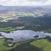
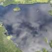
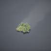
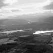
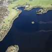
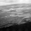
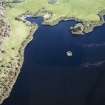
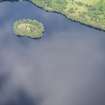
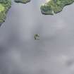
Prison Island, Loch Kinord


Crannog (Period Unassigned)
Site Name Prison Island, Loch Kinord
Classification Crannog (Period Unassigned)
Alternative Name(s) Loch Kinnord; Loch Canmor
Canmore ID 33984
Site Number NO49NW 17
NGR NO 44348 99517
Datum OSGB36 - NGR
Permalink http://canmore.org.uk/site/33984


- Council Aberdeenshire
- Parish Glenmuick, Tullich And Glengairn
- Former Region Grampian
- Former District Kincardine And Deeside
- Former County Aberdeenshire
NO49NW 17 4433 9952
(NO 4433 9952) Tolbooth (NR)
OS 6"map, Aberdeenshire, 2nd ed., (1902).
See also NO49NW 34.
A small circular island believed to have been used as a prison for the nearby castle (NO49NW 16). There can still be seen wooden stakes driven vertically into it.
Name Book 1866.
A wholly artificial crannog 25 yards by 21 yards and 8 1/2 feet high, formed by oak piles with interlacing horizontal beams and stone infilling It is now overgrown. It pre-dates the nearby castle, but it has probably been enlarged during the time the castle was occupied. It is believed that it was used as the prison of the castle.
J G Michie 1910.
A crannog now measuring 20.0m by 14.0m and 1.2m in height consisting of small boulders. No oak piling nor any other artificial features can be seen.
Visited by OS (N K B) 15 November 1968.
Listed.
Scottish Castle Survey 1988; N Bogdan and I B D Bryce 1991.
Underwater Archaeology (7 March 2015 - 31 October 2015)
NO 44350 99523 This work was carried out, 7–8 March and 16–31 October 2015, as part of a wider project investigating crannogs in NE Scotland and forms a large part of the author’s PhD research. A submerged survey was undertaken of Prison Island, Loch Kinord, in March and measured the extent of the rubble matrix that makes up the crannog. The visibility conditions in the loch were exceptionally poor, limiting the features identified to the rubble matrix only and two horizontal timbers. One of these timbers, located on the S side of the crannog, in 1.6m of water and emerging from the rubble matrix, was sampled and radiocarbon dated. The sample returned a date of 925±30 BP or cal AD1026–1170 and AD1176–1182 (95.4% probability – Poz–72879).
In October, the opportunity was taken to return to Prison Island to excavate a 1 x 1m trench to test if there were surviving archaeological deposits above the waterline. It was discovered that only a peaty soil survives above the waterline between the stones which make-up the rubble matrix of the island. Below the waterline, the trench revealed in situ charcoal-rich deposits which were sampled. A fragment of charred roundwood was identified and will be sent for radiocarbon dating.
Archive: Aberdeenshire SMR and National Record of the Historic Environment (NRHE) intended
Funder: Aberdeen Humanities Fund/Society of Antiquaries of Scotland
Michael J Stratigos – University of Aberdeen
(Source: DES, Volume 16)

