
Loch Kinord


Building(S) (Period Unassigned), Motte (Medieval)
Site Name Loch Kinord
Classification Building(S) (Period Unassigned), Motte (Medieval)
Alternative Name(s) Gardybien; Gardiebane; Loch Kinnord; Loch Canmor
Canmore ID 33979
Site Number NO49NW 11
NGR NO 4442 9900
Datum OSGB36 - NGR
Permalink http://canmore.org.uk/site/33979


- Council Aberdeenshire
- Parish Glenmuick, Tullich And Glengairn
- Former Region Grampian
- Former District Kincardine And Deeside
- Former County Aberdeenshire
NO49NW 11 4442 9900
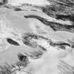
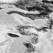
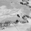
(NO 444 989) A peninsula on the south side of Loch Canmor (Loch Kinord) has been cut off from the land by a fosse which had communicated at each end with the water of the loch, but which is now dry. Over this fosse had been a drawbridge, the site of which is distinctly visible; and the road to and from it was only taken up by the present tenant of Meikle Kinord. On the side of the peninsula next the land are very distinct remains of a rampart, 100 paces in length, ending in an apex or angle at the site of the drawbridge. There are the foundations of two small buildings, not of any antiquity, on the top. The area is known locally as Gardybein but nothing else is known about it.
J Stuart 1868.
The peninsula, called Gardiebane by Michie (1910) has a fosse and double wall running across its neck. A small ancient hut-foundation can be seen at the east end of the fosse (A Ogston 1931) There are faint traces of a rampart around the peninsula (J G Michie 1910).
J G Michie 1910; A Ogston 1931.
Gardybien or Gardiebane (name not confirmed locally) is centred at NO 4442 9900 and consists of a low promontory, extending into Loch Kinnord, across the neck of which a substantial earthern rampart and ditch have been constructed. Along the top of the rampart, which attains a maximum height of 3.0m above the bottom of the ditch, there is a collapsed stone wall about 2.0m in width and 0.8m in height. A later retaining wall has been built against the outer edge of the ditch. No trace of a drawbridge could be found and apart from a scatter of stone around the N. end, no evidence of " a rampart around the peninsula" was seen. The "hut foundation" described by Ogston is a clearance heap, probably associated with the two later rectangular buildings within the enclosed area.
This is clearly not a prehistoric earthwork. The available evidence points to a medieval date, suggesting that in all probability it is an early-type motte, possibly the precedence of the castle in Loch Kinord. (NO49NW 16)
Surveyed at 1/2500.
Visited by OS (A C), 6 March 1969.
Listed.
Scottish Castle Survey 1988; N Bogdan and I B D Bryce 1991.
Classified as Fort by Aberdeenshire Archaeological Service.
NMRS, MS/712/17.
GRC/AAS photography listed.
NMRS, MS/712/19.
Excavation (2 March 2015 - 6 March 2015)
NO 44450 98930 This work, 2–6 March 2015, formed part of the Living by the Loch: human occupation and landscape history at Loch Kinord Project, which sought to add contextual information to the range of artefacts held in Aberdeen University’s Marischal Museum Collections. The work included an excavation on the Gardiebane Peninsula and radiocarbon dating of two artefacts.
Located on the southern shore of Loch Kinord, the Gardiebane Peninsula is recorded in the Canmore database as building(s) and motte (NO49NW 11) at NO 4442 9990, and as a possible promontory fort/motte in the Aberdeenshire SMR. It is labelled on OS survey maps as a fort or earthwork. The site is perhaps better classified as an inland water promontory fort. It consists of two banks and ditches which cut the peninsula off from the mainland. The inner bank rises c3m above an outer ditch. The confused classification echoes the lack of an obvious period to which to assign the site. A topographic survey was undertaken using DGPS to generate a dataset of points with height values. These points were then used to create a digital elevation model.
Two trenches were excavated by hand. Initially, only a single trench through the outer ditch and bank was to be opened. The first trench (TT1) extended from the middle of the outer bank to the middle of the outer ditch and measured 3 x 1m. It was decided at the closing of TT1, which produced little potential for radiocarbon dating the earthwork, to open a second trench through the inner bank and ditch (TT2). This trench was also laid from the middle of the inner bank to the middle of the inner ditch and measured 2 x 1m. The excavations revealed that the bank is composed of redeposited natural material, probably of glacial origin.
TT1 demonstrated that the outer ditch and related walling appears to have been re-cut and the N-facing walling on the inside of the outer bank relates to this later activity.
In TT2, a section was put through the bank which revealed the former land surface. A sample of carbonised wood from this context was radiocarbon dated to 4295±35BP, or cal 3012–2878BC (95.4% probability – Poz-72769). This date is not likely to represent an immediate terminus post quem for the Gardiebane earthworks, rather it appears that the inner bank was built on top of this Neolithic land surface. The actual date for construction of the banks and ditches remains unspecific, and by comparison to other similar earthworks could date from the Late Bronze Age to the early medieval period.
On the 14 May 2015 samples were taken from two artefacts for radiocarbon dating. A sterilised small drill bit was used to remove a sample from a logboat fragment. The radiocarbon result was 1460±30 BP, or cal AD553–648 (95.4% probability – Poz-71094). This date must be treated with caution and some consideration given to the fragmentary nature of the artefact, which did not enable the sample location to be determined in relation to the ring-structure of the tree. A small drill bit was used to remove a sample from a wooden, probably oak, spearhead shaft. The radiocarbon result was 2720±30 BP, or cal 918BC–811BC (95.4% probability – Poz-71093).
Archive: Aberdeenshire SMR and National Record of the Historic Environment (NRHE) intended
Funder: Aberdeen Humanities Fund
Michael J Stratigos – University of Aberdeen
(Source: DES, Volume 16)
Note (25 May 2015 - 19 October 2016)
This low-lying promontory jutting out from the southern shore of Loch Kinord has been cut off from the land on the S by a bank with external ditch drawn in an arc across its neck. The bank is capped by a collapsed stone dyke and stands up to 3m above the bottom of the ditch, the counterscarp of which is also revetted by a later dyke. The interior, which measures about 95m from NNW to SSE by up to 85m transversely (0.6ha), contains footings of two rectangular buildings. According to John Stuart, writing in the mid 19th century, there had been a metalled roadway leading to what he took to be a drawbridge across the ditch (1866, 169-70). Most recently two small trenches were excavated across elements of the perimeter (Stratigos 2015), but failed to elucidate anything of the date or character of this earthwork.
Information from An Atlas of Hillforts of Great Britain and Ireland – 19 October 2016. Atlas of Hillforts SC3075

