
Following the launch of trove.scot in February 2025 we are now planning the retiral of some of our webservices. Canmore will be switched off on 24th June 2025. Information about the closure can be found on the HES website: Retiral of HES web services | Historic Environment Scotland
Forfar, General


Burgh (Medieval), Town (Medieval) - (Post Medieval)
Site Name Forfar, General
Classification Burgh (Medieval), Town (Medieval) - (Post Medieval)
Canmore ID 33831
Site Number NO45SE 80
NGR NO 4565 5061
Datum OSGB36 - NGR
Permalink http://canmore.org.uk/site/33831


- Council Angus
- Parish Forfar
- Former Region Tayside
- Former District Angus
- Former County Angus
Note (1978)
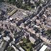
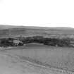
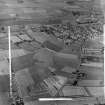
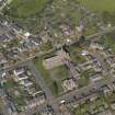
Forfar
The site of Forfar Castle (NO 456 508) was in use during the 11th century and the town became a royal burgh by about the mid-12th century.
RCAHMS 1978
(Reid 1902, 1-25; Pryde 1965, 12-13, no. 23)

