
Pricing Change
New pricing for orders of material from this site will come into place shortly. Charges for supply of digital images, digitisation on demand, prints and licensing will be altered.
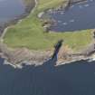
Stronsay, Lamb Head


Settlement (Period Unassigned)(Possible), Polisher (Period Unassigned), Unidentified Pottery (Iron Age)
Site Name Stronsay, Lamb Head
Classification Settlement (Period Unassigned)(Possible), Polisher (Period Unassigned), Unidentified Pottery (Iron Age)
Canmore ID 3366
Site Number HY62SE 24
NGR HY 6896 2154
Datum OSGB36 - NGR
Permalink http://canmore.org.uk/site/3366


- Council Orkney Islands
- Parish Stronsay
- Former Region Orkney Islands Area
- Former District Orkney
- Former County Orkney
HY62SE 24 6896 2154.
80m NW of Lamb Head broch (HY62SE 1), are turf-covered remains, spread to 4m thick, of wall running obliquely NW-SE across promontory, does not appear to be defensive but may be associated with broch.
Visited by OS, July 1970
A semicircular mound of earth and stone about 22.5m N-S x 5m E-W, with its straight side against the shore banks, maximum height 1.1m. A slot recently cut through at its S end to accommodate a fence, reveals a dense limpet shell midden.
About 5m out from the mound on the SW side is a bank concentric with the mound; this is the bank described by the OS.
RCAHMS 1984; visited (R G Lamb) July 1979.
A slot cut for a fence revealed a sherd of possibly EIA pottery and a rounded beach pebble used as a polisher, together with a limpet scatter.
D Lynn and B Bell 1989b.

