
Pricing Change
New pricing for orders of material from this site will come into place shortly. Charges for supply of digital images, digitisation on demand, prints and licensing will be altered.
Upcoming Maintenance
Please be advised that this website will undergo scheduled maintenance on the following dates:
Thursday, 9 January: 11:00 AM - 3:00 PM
Thursday, 23 January: 11:00 AM - 3:00 PM
Thursday, 30 January: 11:00 AM - 3:00 PM
During these times, some functionality such as image purchasing may be temporarily unavailable. We apologise for any inconvenience this may cause.
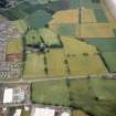
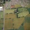
Westfield


Enclosure (Prehistoric)
Site Name Westfield
Classification Enclosure (Prehistoric)
Canmore ID 33584
Site Number NO44NW 14
NGR NO 44402 49770
Datum OSGB36 - NGR
Permalink http://canmore.org.uk/site/33584


- Council Angus
- Parish Forfar
- Former Region Tayside
- Former District Angus
- Former County Angus
Note (1983)
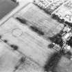
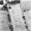
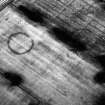
Westfield 3 NO 444 497 NO44NW 14
Cropmarks reveal a circular enclosure, measuring 50m in diameter within its ditch, about l00m NNW of Westfield farmhouse.
RCAHMS 1983.
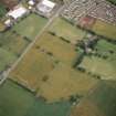
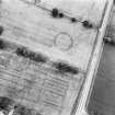
Aerial Photographic Transcription (9 October 2017)
An interpretative transcription, or mapping, of information on oblique aerial photographs was produced on 9 October 2019.

