
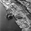
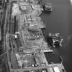
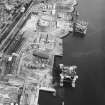
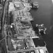
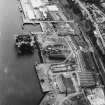
Dundee, Stannergate, Caledon East Wharf


Wharf (Period Unassigned)
Site Name Dundee, Stannergate, Caledon East Wharf
Classification Wharf (Period Unassigned)
Alternative Name(s) Dundee Harbour; Port Of Dundee; River Tay; Firth Of Tay
Canmore ID 33525
Site Number NO43SW 64
NGR NO 42915 30765
Datum OSGB36 - NGR
Permalink http://canmore.org.uk/site/33525


- Council Dundee, City Of
- Parish Dundee (Dundee, City Of)
- Former Region Tayside
- Former District City Of Dundee
- Former County Angus
NO43SW 64 42915 30765
Location formerly cited as NO 432 309.
For general summary of Dundee Harbour and the Port of Dundee, see NO43SW 109.
Caledon East Wharf [NAT]
OS (GIS) AIB, April 2006.
The location assigned to this record defines the centre of the length of the wharf. The available map evidence indicates that it extends from NO 42841 30750 to NO 42987 30775.
Information from RCAHMS (RJCM), 18 April 2006.

