
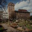
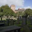
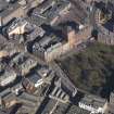
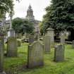
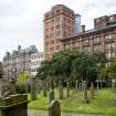
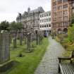
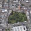
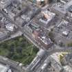
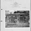
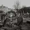
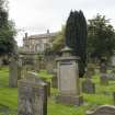
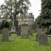
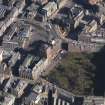
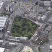
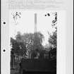
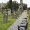
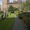
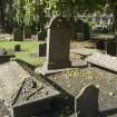
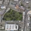
Dundee, Barrack Street, The Howff


Burial Ground (16th Century), Cemetery (16th Century)
Site Name Dundee, Barrack Street, The Howff
Classification Burial Ground (16th Century), Cemetery (16th Century)
Alternative Name(s) The Houff; Meadowside; Old Burial Ground
Canmore ID 33479
Site Number NO43SW 22
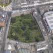
NGR NO 40152 30357
NGR Description Centred on NO 40152 30357
Datum OSGB36 - NGR
Permalink http://canmore.org.uk/site/33479


- Council Dundee, City Of
- Parish Dundee (Dundee, City Of)
- Former Region Tayside
- Former District City Of Dundee
- Former County Angus
NO43SW 22 40152 30357.
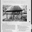
(Centred NO 40152 30357) The Houff or Old Burial Ground (NAT)
OS 25" map, (1959)
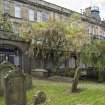
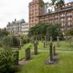
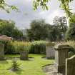
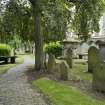
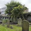
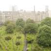
In 1564 Queen Mary granted the burgh permission to use the former yard of the Franciscan Friary (NO43SW 11) as a public burial ground. In 1601, the early walls were replaced by a heavy wall which still exists on the W side.
A Jervise 1861; Kidd 1909.
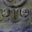
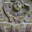
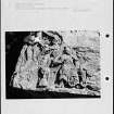
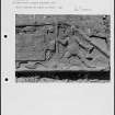
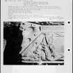
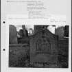
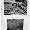
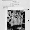
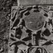
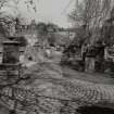
NO 4008 3037 - NO 4009 3034 and NO 4011 3029 - NO 4012 3028. Two stretches of the 17th century wall remaining, all the other walls being modern. Many of the gravestones bear early and mid-17th century dates.
Visited by OS (J L D) 17 April 1958.
NMRS REFERENCE:
Dundee, Barrack Street, The Howff.
Architect: David Neave - wall & railings at Meadowside 1828
James Black - gateway to Barrack Street 1833
Plans:
Dick Peddie & MacKay, Edinburgh. Measured survey. Gravestones.
Attic 2, Bin 32, Bag 1. c. 1943.
Watching Brief (1998)
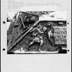
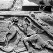
A watching brief by SUAT Ltd in 1998 on a pipe trench at the eastern corner of this graveyard revealed fragments of disarticulated human bone and a headstone, re-used as paving-slab adjacent to a stand-pipe. The bones were reburied and the gravestone was moved to a safe place. There were no other finds.
This small-scale development comprised connecting the outflow from a stand-pipe adjacent to a small brick-built outbuilding used by the Council staff as a mess room, and a new portaloo which is to be sited next to the building, to an existing outflow pipe 2m away buried beneath a gravel path. This was later revised when the pipe could not be located. Instead, a much longer trencg was cut to connect the new pipe to an existing pipe which runs beneath the cobbled path parallel to the tenement buildings which form the north-east boundary of the site.
The c 15m long trench, which was cut by machine to a depth of 0.7m and to a width of 0.7m, was cut through the gravel path and skirted very close to several headstones. The fill of tbhe trench comprised a much disturbed stony graveyard soil (dark brown clay loam), with moderate small to medium fragments of disarticulated human bone and occasional ceramic pipe stems. No evidence of articulated burials were observed, which are likely to be much more deeply buried. No finds were collected.
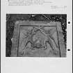
In addition, a headstone which had been re-used as a paving slab by the stand-pipe, was removed and put aside in a safe place. The stone had been broken in antiquity and the engraving was difficult to translate. For future reference, the stone can be found propped up against a wall on a concrete ledge behind the new fenced enclosure.
Information from SUAT, 1998
Scottish Urban Archaeological Trust. 1995. A Watching Brief at the Howff, Dundee
Watching Brief (2000)
A watching brief by SUAT Ltd in 2000 on the replacement of a flower bed along the north side of the graveyard revealed fragments of human bone, which were reburied on site, as well as modern ceramic bottles and clay pipe stems. Foundations of a former lavatory and telephone box (both of 1960's OS maps) were found.
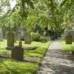
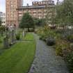
In the border east of the north gate headstones were still in place, indicating that this area has remained undisturbed, except for planting, since the burial ground went out of use in 1836. More bone fragments were encountered in this area than on the west side because the graveyard soil here had not been sealed by a gravel pathway.
On the west side of the north gate the burial ground had been largely sealed by a former gravel pathway and make up, except at the extreme north end.
In recent times two features had been cut through the original wall. These are shown on the 1960's Ordnance Survey maps as a lavatory on the west side of the gate where the brick wall was found and further to the west, a telephone box at the location of the concrete base or plinth. The present border here had been established over the old gravel pathway, and the new cassie set pathway laid out about 1984.
Because of the shallowness of the ground preparation no archaeological horizons relating to the Greyfriar's friar were encountered and no in situ burials were disturbed.
Scottish Urban Archaeological Trust. 2000. A Watching Brief at the Howff, Dundee.
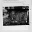
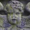
Photographic Survey (9 September 2010)
Photographed by RCAHMS on behalf of the Buildings of Scotland.
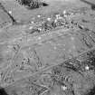
Measured Survey (April 2017)
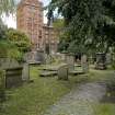
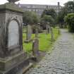
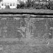
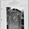
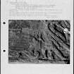
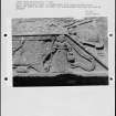
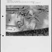
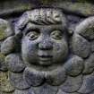
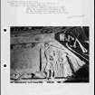
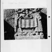
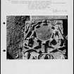
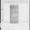
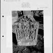
NO 40152 30357 (NO43SW 22) A detailed mapping survey was commissioned by Dundee Howff Conservation Group of all the gravestones, burial monuments, walls and paths within the Howff burial ground. In April 2017 two robotic total stations and a survey grade GPS device were used to undertake the survey. The positions were recorded of 1751 burial monuments and several additional stray fragments. This included a previously unrecognised medieval coped gravestone dating from the 12th or 13th century which was discovered near the NW side of the cemetery. A photographic and written record of the monuments was also taken with the assistance of community volunteers.
Archive: Dundee City Council and NRHE (intended)
Funder: Dundee City Council
Oliver O’Grady – OJT Heritage
(Source: DES, Volume 18)

