
Pricing Change
New pricing for orders of material from this site will come into place shortly. Charges for supply of digital images, digitisation on demand, prints and licensing will be altered.
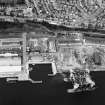
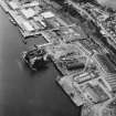
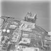
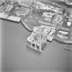
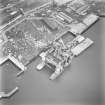
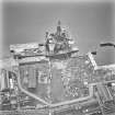
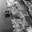
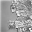
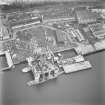
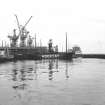
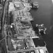
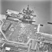
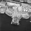
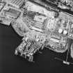
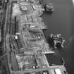
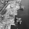
Dundee, Stannergate Road, Caledon Shipyard


Shipyard (19th Century)
Site Name Dundee, Stannergate Road, Caledon Shipyard
Classification Shipyard (19th Century)
Alternative Name(s) Davy G.v.a. Ltd; Dundee Harbour; Port Of Dundee; River Tay; Firth Of Tay
Canmore ID 33464
Site Number NO43SW 114
NGR NO 4279 3087
NGR Description Centred NO 4279 3087
Datum OSGB36 - NGR
Permalink http://canmore.org.uk/site/33464


- Council Dundee, City Of
- Parish Dundee (Dundee, City Of)
- Former Region Tayside
- Former District City Of Dundee
- Former County Angus
NO43SW 114 centred 4279 3087
For general summary of Dundee Harbour and the Port of Dundee, see NO43SW 109.
Caledon Shipyard [NAT]
OS 1:10,000 map, 1984.
Publication Account (2013)
CALEDON SHIPYARD, Stannergate Road: Operated by W B Thompson later known as Caledon, then Robb Caledon, 1874-1981, the yard now repairs North Sea oil rigs, its large steel-framed fabrication shops re-clad in profiled metal sheeting. A bridge over the railway allowed the workforce direct access to the yard.
The associated engine works was originally Tay Foundry, Mains Loan, a considerable distance inland and uphill, requiring marine engines to be hauled by traction engine. The drawing offices, with a domed
glass centrepiece, were demolished in the 1990s. See NO43SW 115 for the Caledon Boiler shop.
M Watson, 2013

