
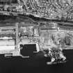
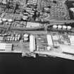
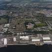
Dundee, Stannergate, Caledon Street, Eastern Wharf


Transit Shed(S) (19th Century), Wharf (20th Century)
Site Name Dundee, Stannergate, Caledon Street, Eastern Wharf
Classification Transit Shed(S) (19th Century), Wharf (20th Century)
Alternative Name(s) Dundee Harbour; Port Of Dundee; River Tay; Firth Of Tay
Canmore ID 33463
Site Number NO43SW 113
NGR NO 42322 30696
Datum OSGB36 - NGR
Permalink http://canmore.org.uk/site/33463


- Council Dundee, City Of
- Parish Dundee (Dundee, City Of)
- Former Region Tayside
- Former District City Of Dundee
- Former County Angus
NO43SW 113 42322 30696
Location formerly cited as centred NO 42412 30721.
For general summary of Dundee Harbour and the Port of Dundee, see NO43SW 109.
For ferry terminal at NO 42460 30701, see NO43SW 1003.
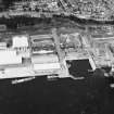
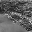
Eastern Wharf [NAT]
OS (GIS) AIB, April 2006.
This wharf occupies a length of the N bank of the River Tay.
The location assigned to this record defines the centre of the length of the wharf. The available map evidence indicates that it extends from NO 42220 30678 to NO 42440 30711.
Information from RCAHMS (RJCM), 18 April 2006.
Publication Account (2013)
EASTERN WHARF: The first reinforced concrete structure in the docks, and the first such bridge in Scotland, 1903, carried a railway across a former ship launching slip at Marine Parade, demolished in 1992. Satisfied with its performance in load tests, the Dundee Harbour Board commissioned more
reinforced concrete wharves fronting the Tay, all by the Yorkshire Hennebique Contracting Company: Eastern Wharf, 1903-09 is 1,240.79m (790ft) in length; King George V Wharf, 444.7m (1,459 ft) in length, and Western Wharf followed suit to either side of Camperdown Dock entrance. Cranes by Stothert and Pitt, Bath.
M Watson, 2013

