
Pricing Change
New pricing for orders of material from this site will come into place shortly. Charges for supply of digital images, digitisation on demand, prints and licensing will be altered.
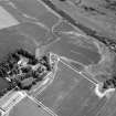
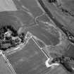
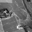
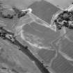
Auldtown Of Netherdale


Pit(S) (Period Unassigned), Ring Ditch(S) (Period Unassigned), Roundhouse(S) (Prehistoric)(Possible), Unenclosed Settlement (Period Unassigned)
Site Name Auldtown Of Netherdale
Classification Pit(S) (Period Unassigned), Ring Ditch(S) (Period Unassigned), Roundhouse(S) (Prehistoric)(Possible), Unenclosed Settlement (Period Unassigned)
Alternative Name(s) Old Town Of Netherdale
Canmore ID 332396
Site Number NJ64NW 77
NGR NJ 6394 4767
Datum OSGB36 - NGR
Permalink http://canmore.org.uk/site/332396


- Council Aberdeenshire
- Parish Marnoch
- Former Region Grampian
- Former District Banff And Buchan
- Former County Banffshire
Aerial Photography (7 July 1984)

