
Pricing Change
New pricing for orders of material from this site will come into place shortly. Charges for supply of digital images, digitisation on demand, prints and licensing will be altered.
North Sutor, Coast Battery, Port War Signal Station


Flagpole (First World War), Naval Signal Station (First World War), Radio Mast (First World War) (1913)(Possible)
Site Name North Sutor, Coast Battery, Port War Signal Station
Classification Flagpole (First World War), Naval Signal Station (First World War), Radio Mast (First World War) (1913)(Possible)
Alternative Name(s) Cromarty Defences, Fort North Sutor, Site No. 1
Canmore ID 331901
Site Number NH86NW 9.20
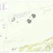
NGR NH 81880 68915
Datum OSGB36 - NGR
Permalink http://canmore.org.uk/site/331901


- Council Highland
- Parish Nigg (Ross And Cromarty)
- Former Region Highland
- Former District Ross And Cromarty
- Former County Ross And Cromarty
Note (30 July 2013)
On a plan of the site (The National Archives WO 78/5192) dated 1922 there is a building annotated 'War Signal Station', with a mast base immediately to the S of it. This is the Port War Signal Station which would have monitored all shipping moving past the batteries.
Information from RCAHMS (AKK) 30 July 2013.
Project (March 2013 - September 2013)
A project to characterise the quantity and quality of the Scottish resource of known surviving remains of the First World War. Carried out in partnership between Historic Scotland and RCAHMS.
Field Visit (26 March 2019)
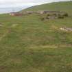
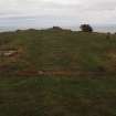
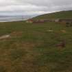
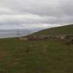
This grass-grown concrete building platform, which is situated on the crest of the scarp overlooking the Cromarty Firth, formed part of the infrastructure of the battery introduced by the Admiralty in World War 1. It is rectangular on plan and measures 6.2m from E to W by 3.05m transversely within brick walls 0.3m thick. A central partition running from N to S suggests that it was divided into two equal compartments, while a broad threshold on the N reveals that each could have been accessed by a separate doorway.
Three square concrete pads forming an inverted triangle are situated on the crest of the scarp immediately S of this building. Each pad is flush with the ground and retains the remains of an iron stake projecting from its upper surface. The more northerly pair measures 0.9m square, while that to their S measures 1.3m square.
The building is identified as a ‘War Signal Station’ on a plan held by the National Archives at Kew (WO78/5192: 16/19), which also indicates that the pads were part of a quincunx-shaped setting forming the four anchor points of a central ‘flagstaff’ - perhaps more likely a radio mast. Two further pads to the S have been destroyed by quarrying; but the original setting may have once measured about 5m square. It is also shown on a sketch map of the battery entitled 'Telephone Circuits' (ADM7/942), dated 7 May 1919, which labels it with the abbreviation 'PWSS' (Port War Signal Station). In addition, the mast can also be glimpsed in a photograph taken from the NW on 28 March 1913 during the construction of the battery (SC1116243).
Visited by HES, Survey and Recording (ATW, AKK), 26 March 2019.

