
Clyde Defences, Portkil Battery Land Defence, Millbrae, No. 4 Position


Blockhouse(S) (First World War), Building (First World War), Latrine (First World War), Trench (First World War)
Site Name Clyde Defences, Portkil Battery Land Defence, Millbrae, No. 4 Position
Classification Blockhouse(S) (First World War), Building (First World War), Latrine (First World War), Trench (First World War)
Canmore ID 331751
Site Number NS28SE 39.16
NGR NS 24950 81390
NGR Description Centred on NS 24729 8190
Datum OSGB36 - NGR
Permalink http://canmore.org.uk/site/331751


- Council Argyll And Bute
- Parish Rosneath
- Former Region Strathclyde
- Former District Dumbarton
- Former County Dunbartonshire
War Office maps dated 1916 (The National Archives WO 78/4396) show the location of a group of defensive structrues labelled "No. 4 Position" as part of the outer defences of Portkil Battery during the First World War. Two "blockhouses" (pillboxes) are marked at (No. 7) NS 24729 81345 and NS 25119 81391, with trenches at NS 25115 81552. Two latrines annotated E.C and 'Earth closet', and a 'Shed' are also marked, as well as an Officers' hut at NS 24991 81360.
Information from HS/RCAHMS World War One Audit Project (GJB) 15 July 2013.
Project (March 2013 - September 2013)
A project to characterise the quantity and quality of the Scottish resource of known surviving remains of the First World War. Carried out in partnership between Historic Scotland and RCAHMS.
Field Visit (26 September 2016)
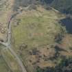
The First World War defences to the SE and SW of the small mill pond on the Kilcreggan Burn east of Millbrae Plantation form part (No.4 Position) of a larger infrastructure designed to protect the Portkil Coastal Battery (NS28SE 39) from its landward side (see also NS28SW 5, NS28SW 30, NS28SE 39.15 and 17). According to a contemporary plan (WO78/4396) No.4 Position comprised two blockhouses (No.7 and No.8), one firing trench, an officer’s hut, a shed and two earth closets.
Blockhouse No.7 (NS 24732 81347) stood to the rear of a dry-stone wall on an ESE-facing slope some 260m SW of the mill pond. The wall, supplemented by sand bags, is likely to have formed the front (east side) of the blockhouse but the only other visible evidence of the structure is a short length of thick bank that runs up against the rear of the wall and probably defined the south side of the blockhouse. Nothing is now visible within an area heavily disturbed by forestry ploughing of an earth closet (NS c. 2473 8131) depicted no more than 20m SE of the blockhouse, on the opposite side of a deep drain.
Blockhouse No.8 (NS 25126 81406) is situated 130m SE of the mill pond, on the SE-facing crest of a low, un-named hillock E of the Kilcreggan Burn. Roughly oval on plan, it has originally measured about 7m from NW to SE by 6m transversely within a wall, but except on the SW, where it has been reduced to a barely perceptible bank at least 1.5m in thickness, there is no visible trace of this wall. A shallow external ditch, which runs clockwise from the NNW around to the W and probably served both as a drain and a source of material for the original bank, measures at least 2m in breadth. Immediately NW of the wide (6.2m) gap in the ditch on the NW there is an 10m long trench that arcs round from N to NW. It is depicted on the War Office plan but its function is not known. Also depicted on the plan is a shed (NS 25115 81387) that stood 13m SW of the blockhouse. All that remains visible of its presence is a grass-grown rectangular stance measuring about 3.4m from NNE to SSW by 2.7m transversely, its ESE side marked by a low, outer-facing scarp. On the date of visit no trace was found in rough pasture of either the Officer’s hut (NS c. 2499 8138), which stood about 120m WSW of Blockhouse No.8, the earth closet (NS c. 2512 8145), which stood about 40m to the N of the blockhouse, or the firing trench (NS c. 2522 8154) which was situated towards the foot of the N flank of the hillock, some 130m N of the blockhouse and in an area obscured by very dense vegetation on the date of visit. A feature that is not depicted on the contemporary plan is a firing trench (NS 25183 81467) that is situated on the east flank of the hillock 75m NE of the blockhouse. It comprises a straight trench measuring 21.5m from NNW to SSE by up to about 1.2m in breadth and 0.3m in depth, fronted on the ENE by a low, flat-topped bank approximately 2.5m in thickness. A drain runs out the south end of the trench.
Visited by HES, Survey and Recording (JRS, AK, AM) 26 September 2016.
Measured Survey (27 September 2016)
HES surveyed Blockhouse No.8 and the trench at Portkil Battery landward defences (Position No.4) on 27 September 2016 with plane-table and alidade, both at a scale of 1:200. The resultant plans were redrawn in vector graphics software at a scale of 1:500.

