
Pricing Change
New pricing for orders of material from this site will come into place shortly. Charges for supply of digital images, digitisation on demand, prints and licensing will be altered.
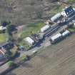
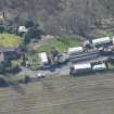
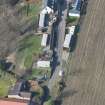
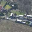
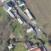
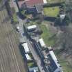
Clyde Defences, Portkil Battery


House (20th Century), Military Building (20th Century)(Possible)
Site Name Clyde Defences, Portkil Battery
Classification House (20th Century), Military Building (20th Century)(Possible)
Canmore ID 331703
Site Number NS28SE 39.13
NGR NS 25051 80490
Datum OSGB36 - NGR
Permalink http://canmore.org.uk/site/331703


- Council Argyll And Bute
- Parish Rosneath
- Former Region Strathclyde
- Former District Dumbarton
- Former County Dunbartonshire
Note (5 July 2013)
A single roofed building located between Fort Road and the metal fence of the coast battery. It does not appear on the plan of Portkil battery dated 1908 and 1916.
Information from RCAHMS (AKK) 5 July 2013
Field Visit (28 September 2016)
What may be a building of military origin, now in use as a dwelling, stands only 13m NNW of the 4.7-inch gun emplacement (NS28SE 39.02) but on the opposite side of Fort Road. However, it is not depicted on any of the readily accessible plans of Portkil battery dated 1908 and 1916. Close inspection of the structure was not possible on the date of visit.
Visited by HES Survey and Recording (AKK) 28 September 2016.

