|
Photographs and Off-line Digital Images |
F 10681 |
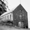
List C Survey |
General view |
1975 |
Item Level |
|
 |
On-line Digital Images |
DP 075813 |
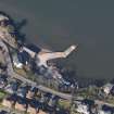
RCAHMS Aerial Photography Digital |
Oblique aerial view centred on the remains of the flying boat base with the harbour adjacent, taken from the SE. |
10/3/2010 |
Item Level |
|
 |
On-line Digital Images |
DP 075814 |
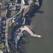
RCAHMS Aerial Photography Digital |
Oblique aerial view centred on the remains of the flying boat base with the harbour adjacent, taken from the E. |
10/3/2010 |
Item Level |
|
 |
On-line Digital Images |
DP 075816 |
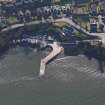
RCAHMS Aerial Photography Digital |
Oblique aerial view centred on the remains of the flying boat base with the harbour adjacent, taken from the N. |
10/3/2010 |
Item Level |
|
 |
On-line Digital Images |
SC 1636578 |
List C Survey |
General view |
1975 |
Item Level |
|
 |
On-line Digital Images |
SC 2405791 |
Records of the Ordnance Survey, Southampton, Hampshire, England |
Newport-On-Tay, Woodhaven Pier, Joiner's Workshop, NO42NW 47, Ordnance Survey index card, Recto |
c. 1958 |
Item Level |
|
|
Manuscripts |
MS 2669/1 |
Historic Scotland Archive Project |
Survey archive: Photographic register for Coastal Assessment Survey for Historic Scotland, Fifeness to Newburgh. Second version of photographic register. |
9/1996 |
Batch Level |
|
|
Photographs and Off-line Digital Images |
BP 72/13 |
Historic Scotland Archive Project |
Survey photographs: Newport ferry pier, private mooring, worked stones and trackway on beach, Woodhaven harbour and wreck off Wormit. |
10/1996 |
Batch Level |
|
|
Manuscripts |
MS 2669/2 |
Historic Scotland Archive Project |
Survey archive: Erosion and Geology map sheets from Coastal Assessment Survey for Historic Scotland, Fifeness to Newburgh.
Map 8 from both Erosion and Geology are not included with the archive. |
9/1996 |
Batch Level |
|


