|
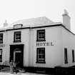
Photographs and Off-line Digital Images |
F 10841 |
List C Survey |
General view of hotel frontage |
1975 |
Item Level |
|
|
Photographs and Off-line Digital Images |
F 10842 |
|
Oblique view of hotel, distant view of Tay Rail Bridge |
1975 |
Item Level |
|
|
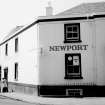
Photographs and Off-line Digital Images |
DP 126459 |
Buildings at Risk Register |
The Newport Hotel Front elevation |
14/12/2010 |
Item Level |
|
|
Photographs and Off-line Digital Images |
DP 126460 |
Buildings at Risk Register |
The Newport Hotel Approach from north |
14/12/2010 |
Item Level |
|
|
Photographs and Off-line Digital Images |
DP 126461 |
Buildings at Risk Register |
The Newport Hotel Approach from south |
14/12/2010 |
Item Level |
|
|
Photographs and Off-line Digital Images |
DP 126462 |
Buildings at Risk Register |
The Newport Hotel Side elevation with date stone |
14/12/2010 |
Item Level |
|
|
Photographs and Off-line Digital Images |
DP 204166 |
Buildings at Risk Register |
From South |
18/6/2014 |
Item Level |
|
|
Photographs and Off-line Digital Images |
DP 204167 |
Buildings at Risk Register |
From South West |
18/6/2014 |
Item Level |
|
 |
On-line Digital Images |
SC 1637000 |
List C Survey |
General view of hotel frontage |
1975 |
Item Level |
|
 |
On-line Digital Images |
SC 1637001 |
|
Oblique view of hotel, distant view of Tay Rail Bridge |
1975 |
Item Level |
|
 |
On-line Digital Images |
SC 2405779 |
Records of the Ordnance Survey, Southampton, Hampshire, England |
Newport-On-Tay, 1 High Street, Newport Hotel, NO42NW 35, Ordnance Survey index card, Recto |
c. 1958 |
Item Level |
|
|
Manuscripts |
MS 2669/2 |
Historic Scotland Archive Project |
Survey archive: Erosion and Geology map sheets from Coastal Assessment Survey for Historic Scotland, Fifeness to Newburgh.
Map 8 from both Erosion and Geology are not included with the archive. |
9/1996 |
Batch Level |
|


