
Following the launch of trove.scot in February 2025 we are now planning the retiral of some of our webservices. Canmore will be switched off on 24th June 2025. Information about the closure can be found on the HES website: Retiral of HES web services | Historic Environment Scotland
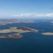
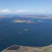
Millburn Bay, Gairsay


Pier (Period Unassigned)
Site Name Millburn Bay, Gairsay
Classification Pier (Period Unassigned)
Canmore ID 331124
Site Number HY42SW 8010
NGR HY 45001 21742
Datum WGS84 - Lat/Long
Permalink http://canmore.org.uk/site/331124


- Council Orkney Islands
- Parish Maritime - Orkney
- Former Region Orkney Islands Area
- Former District Maritime
- Former County Not Applicable
Reference (March 2012)
Sitename : Millburn Bay, Gairsay
Note : Recorded centred at NGR 345001E 1021742N
A submerged pier was located in this area by Kevin Heath (pers. comm).

