
Lucky Scalp


Ballast Mound (19th Century), Beacon (19th Century), Fishing Station (19th Century)
Site Name Lucky Scalp
Classification Ballast Mound (19th Century), Beacon (19th Century), Fishing Station (19th Century)
Canmore ID 33106
Site Number NO42NE 54
NGR NO 4807 2874
Datum OSGB36 - NGR
Permalink http://canmore.org.uk/site/33106


- Council Fife
- Parish Ferry-port-on-craig
- Former Region Fife
- Former District North East Fife
- Former County Fife
NO42NE 54 4807 2874
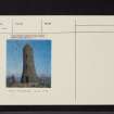
Folly: Lucky Scalp. This tower (published as Land Mark (NAT) on OS 6-inch map, 1959) built on a reef N of Tentsmuir in the mid-19th century, was pulled down in 1979 by order of the District Council.
E Proudfoot 1979; Scots Mag June 1979
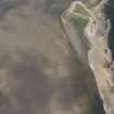
The sandy islet known as Lucky Scalp lies around 2km E of Tayport. Although it appears to be a natural outcrop within the Tayport gravel beds, it has been demonstrated that it is of primarily anthropogenic origin.
Analyses of the component matrix, prompted by the accidental grounding of an oil tanker on the gravel beds, established that they were geologically unrelated to the local glacial deposits. Instead, they bore a marked similarity to gravel deposits around Perth, some 40km upriver.
McManus (1999) suggests that this man-made deposit relates to the dumping of ballast during the 18th and 19th centuries. The material is most likely to have been brought downstream from Perth in lighters [cargo barges] as replacement ballast for sea-going sailing ships moored at Tayport. Any redundant ballast was then discharged at the edge of the tidal flats, forming the island of Lucky Scalp.
It is suggested that these deposits were reworked by salmon fishermen to form a stable platform for hauling in nets. It was on this consolidated base that a 20m high structure was built in the mid-19th century as a salmon fishing station and navigational marker, and it is this which is depicted as a landmark on the 1st edition of the OS 6-inch map (Fife and Kinross, sheet iii, 1855). It is depicted on all subsequent editions until its destruction, and is therefore not shown on the OS 1:10,000 map sheet (1983) or later maps.
Information from Robertson 2003 and McManus 1999
RCAHMS (SO) 2003

