
St Abb's Head


Beacon (Period Unassigned), Building(S) (Period Unassigned), Signalling Structure (19th Century) - (20th Century)
Site Name St Abb's Head
Classification Beacon (Period Unassigned), Building(S) (Period Unassigned), Signalling Structure (19th Century) - (20th Century)
Canmore ID 330144
Site Number NT96NW 204
NGR NT 91239 69149
Datum OSGB36 - NGR
Permalink http://canmore.org.uk/site/330144


- Council Scottish Borders, The
- Parish Coldingham
- Former Region Borders
- Former District Berwickshire
- Former County Berwickshire
Field Visit (16 October 1997)
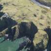
A group of structures located on and between two adjacent knolls and comprising the remains of various maritime signal stations dating from the early-19th to mid-20th centuries. The earliest structure is a small two-roomed rectangular drystone hut, 3.5 x 7.0m, surviving as a low turf-covered mound in a sheltered position in a gully. It was mapped by Sharp, Greenwood & Fowler in 1826 and recorded in ruins by the Ordnance Survey in 1856.
Lloyd's established a signal station in the later 19th century adjacent to the new lighthouse. The signalman's cottage is now demolished and little remains of the signal station which was located on the knoll now the site of the indicator board. Water was obtained from a pump which survives to the west of the signal station. Coastguard cottages, now demolished, were added in 1907 and an area of gardens was laid out between the pump and the signal station at that time. These gardens have been recorded as NMRS site NT96NW 44.
Sponsor: National Trust for Scotland, Historic Scotland
NMRS MS/899/44 (Headland Archaeology Ltd. 16/10/1997)

