
Following the launch of trove.scot in February 2025 we are now planning the retiral of some of our webservices. Canmore will be switched off on 24th June 2025. Information about the closure can be found on the HES website: Retiral of HES web services | Historic Environment Scotland
Lundin Links, Standing Stones Of Lundin


Standing Stone(S) (Prehistoric)
Site Name Lundin Links, Standing Stones Of Lundin
Classification Standing Stone(S) (Prehistoric)
Canmore ID 32656
Site Number NO40SW 1
NGR NO 4048 0272
Datum OSGB36 - NGR
Permalink http://canmore.org.uk/site/32656


- Council Fife
- Parish Largo
- Former Region Fife
- Former District North East Fife
- Former County Fife
NO40SW 1 4048 0272
(NO 4048 0272) Standing Stones of Lundin (NR)
OS 6" map (1971)
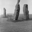
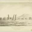
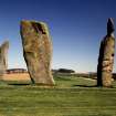
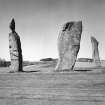
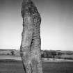
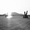
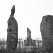
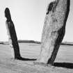
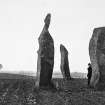
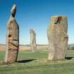
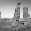
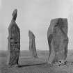
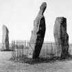
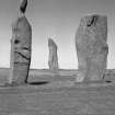
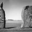
The Standing Stones of Lundin are three tall, unsculptured, irregularly shaped pillars of red sandstone, from about 13'6" to 18' high. Each stone is packed round with small stones. They are probably the remains of a stone circle, 54' in diameter. A fourth stone is known to have existed towards the close of the 18th century. A skull, obtained about 1844 from a "coffin built of loose slabs" which had been exposed immediately adjoining the standing stones, was given to Sir Wm Turner, professor of anatomy, Edinburgh University, by Dr Lumgair of Largo. It was fractured, with a piece of iron that crumbled into rust on being touched, in the fracture.
New Statistical Account 1845; F R Coles 1903; W Turner 1917; RCAHMS 1933, visited 1925.
The stones are as described and illustrated.
Visited by OS (EGC) 16 October 1962.
Scheduled as Standing Stones of Lundin, Links of Lundin.
Information from Historic Scotland, scheduling document dated 23 February 2001.
Field Visit (18 August 1925)
Standing Stones, Lundin Links.
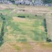
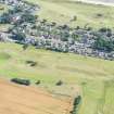
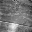
On the north side of the roadway about 400 yards north of the railway station at Lundin Links, on a slightly elevated plateau, which forms part of a golf course, are three tall, unsculptured, and irregularly shaped pillars of red sandstone known as the Standing Stones of Lundin. The New Statistical Account (1) records that "ancient sepukhres are found near them," and they are sometimes spoken of as the burial stones of Danish chiefs. The three surviving stones - for a fourth is known to have been inexistence towards the close of the 18th century - are set in the form of a triangle, the angles of which would fall very evenly upon the circumference of a circle with a diameter of 54 feet. In all probability, therefore, they are the remains of a Stone Circle. Each of them has been packed at the base with a setting of small stones. Although it is not the highest, the one on the south-east, which stands with a slight inclination towards the north and the east, presents the most massive appearance. The girth at the base is 12 feet 8 inches, but measurements taken at 5 feet from the ground give the following dimensions: north face, 5 feet 2 inches; south face, 5 feet; east face, 1 foot 11 inches; west face, 2 feet 2 inches; girth, 14 feet 3 inches; and the stone becomes even wider as its height increases, until near the top where it again shrinks to a very slightly rounded extremity. The height is approximately13 feet 6 inches. The surface is pitted by the action of the weather and shows greatest traces of decay on the east, where a crack has developed. The south stone is set with a decided inclination towards the south. It is of very irregular form with a girth at the base of 9 feet 4 inches, expanding to 10 feet at 5 feet higher up, and suddenly becoming greatly attenuated at the top. The stone, which does not exhibit the same noticeable traces of weathering as the one first described, is approximately 17 feet high. The north stone, which is set with a slight inclination towards the west, appears to be still taller. It rises to a height estimated at 18 feet and has a sharply pointed top. It shows evidence of weathering at the north-west corner. Like the others, it increases in bulk from the base upwards to the middle of its height, the girth being 9 feet 6 inches at the base, and 10 feet 2 inches at 5 feet up. See Proc. Soc. Ant. Scot., xxxvii (1902-3), pp. 212-15.
RCAHMS 1933, visited 18 August 1925.
(1) Vol. ix, p. 438, 1837.xxi S.W.
Publication Account (1987)
This impressive group of stones has been the subject of conjecture for centuries; the New Statistical Account offers the theories current in the 1840s, including a Roman origin, or perhaps the gravestones of Danish chiefs who were defeated by Banquo and Macbeth, or most probably Druidical remains. For the modern prehistorian, the mention of the discovery of 'ancient sepulchres' nearby is an interesting link to other stones, including Orwell (no. 101). An astronomical significance for the stones has also been suggested. There is a pair of stones with a third at a point 30m to the north; in the late 18th century there was a fourth stone which lay broken nearby. The single stone is about 5.5m tall, and the pair measures about 4.1m and 4.6m in height respectively.
Information from ‘Exploring Scotland’s Heritage: Fife and Tayside’, (1987).

