
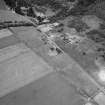
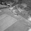
Braehead Farm, Tullich


Souterrain (Prehistoric)
Site Name Braehead Farm, Tullich
Classification Souterrain (Prehistoric)
Canmore ID 32455
Site Number NO39NE 3
NGR NO 3928 9742
Datum OSGB36 - NGR
Permalink http://canmore.org.uk/site/32455


- Council Aberdeenshire
- Parish Glenmuick, Tullich And Glengairn
- Former Region Grampian
- Former District Kincardine And Deeside
- Former County Aberdeenshire
NO39NE 3 3928 9742
For possible souterrain at NO 3934 9751, see NO39NE 103.
A souterrain, recorded by Simpson as having been recently (1941) found at Tullich, was visited in 1965 when its entrance, 2' by 2 1/2' high opened out to a passage 5 1/2' wide by 7' high, with roofing slabs 8' by 3' by 1'.
Visited by OS (D A) September 1965.
W D Simpson 1943.
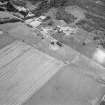
NO 3928 9742. This souterrain is now inaccessible but apparently still intact.
Surveyed at 1/2500.
Visited by OS (N K B) 19 November 1968.
The souterrain is seen on the surface as an entrance surrounded by large stone slabs. No definite surface evidence of the chamber is visible. Descent through the entrance leads to an infilled chamber about 50' long running in a curve from the entrance at the E towards the NW. In the most deeply infilled area just within the entrance, there is evidence of a second chamber running at right angles to the first, towards the SW. This chamber was entered by an entrance with stone uprights and a lintel and now seems completely infilled. The chamber was cleaned out by a group including Mr Pirie of Aberdeen in the 1920's. No finds were made, but the excavator remembered finding a deposit of greyish- white material, presumbaly ash, on the original surface some 4' from the entrance. The fill of the souterrain was clean, white sand indicating possible river flooding at some stage. No report of this work was ever published.
Information contained in letter from R Mowat and F M Wallace to OS, 19 October 1970.
NO 392 974 A resistivity survey was commissioned in order to define the extent of Braehead Farm souterrain (NMRS NO39NE 3) prior to the refencing and re-Scheduling of the monument. The survey successfully identified the northern end of the souterrain as a small high-resistance anomaly. This interpretation was confirmed by a cursory internal examination of the souterrain.
A detailed report has been lodged with the NMRS.
Sponsor: Historic Scotland
B Glendinning 1999

