
Scheduled Maintenance
Please be advised that this website will undergo scheduled maintenance on the following dates: •
Tuesday 3rd December 11:00-15:00
During these times, some services may be temporarily unavailable. We apologise for any inconvenience this may cause.
Castle Hill, Meams


Fort (Prehistoric)
Site Name Castle Hill, Meams
Classification Fort (Prehistoric)
Canmore ID 32228
Site Number NO35NE 6
NGR NO 3615 5681
Datum OSGB36 - NGR
Permalink http://canmore.org.uk/site/32228


- Council Angus
- Parish Kirriemuir
- Former Region Tayside
- Former District Angus
- Former County Angus
NO35NE 6 3615 5681.
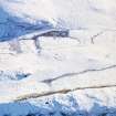
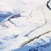
(NO 361 568) The remains of a fort occupying the summit of Castle Hill, a high elongated ridge with low precipices on the north and south. Twenty metres NE of the small modern cairn which occupies the site of the old trig point there is a distinct curving stony bank 3.5m wide, o.5m high internally and 1m high externally. It stops 1m short of the south edge of the ridge, which may indicate an entrance.
About 3.0m beyond this wall, and NE of the cairn is a short couse of large boulders, probably the remains of a wall.
Fifty seven metres SW of the cairn, and a little below the crest of the ridge is the possible course of another wall, a scatter of embedded stones running north-south across the ridge,its scarp slope dropping naturally to the west from 1m on the south to 3m on the north. The possible course of another wall lies across the ridge 14m to the east but it is too indefinite to be certain.
Slight circular depressions about 3m in diameter, beside the fragment of wall NE of the cairn may be the last vestiges of hut circles.
A J Warden 1880-5; A Reid 1909; Information from F T Wainwright 28 May 1958.
NO 3615 5681. This fort is generally as described in the report of 25 September 1958. The area has been disturbed by former tree planting and it seems likely that the circular depressions and the 'short course of large boulders' at the NE of the fort are a result of this disturbance.
Surveyed at 1:2500.
Visited by OS 25 September 1958 and 12 January 1977.
Note (1983)
Castle Hill, Mearns NO 361 568 NO35NE 6
This fort is,situated on the rocky ridge that forms the summit of Castle Hill, 700m WNW of Mearns farmhouse; it comprises an inner dun-like enclosure with traces of outer ramparts, now reduced to stony scarps, enclosing additional areas on the_ ENE and WSW respectively. The entrance is on the SW. Several circular structures overlie the wall of the inner enclosure.
RCAHMS 1983
(Warden 1880-85, iv, 91).
Note (25 May 2015 - 31 May 2016)
This small fortification is situated on the precipitous ridge of outcrop that makes up the summit of Castle Hill to the WNW of Meams farm. No dimensions for the interior have been recorded, but it comprises a small inner enclosure on the very summit, which is girt with cliffs along its SSE and NNW flanks, with outlying ramparts across the spine of the ridge to block access from the ENE and WSW. Leaving aside the small inner enclosure, the interior of the fort measures about 20m in breadth and probably extends for a distance of about 90m WSW from where the upper surface of the ridge comes to a narrow point on the ENE (1.7ha). The defences at the WSW end comprise two ramparts some 14m apart, the inner of which forms a stony scarp from 1m to 3m high. The entrance is on the SW. Several small pens have been built into the rubble of the inner wall.
Information from An Atlas of Hillforts of Great Britain and Ireland – 31 May 2016. Atlas of Hillforts SC3074

