
Pricing Change
New pricing for orders of material from this site will come into place shortly. Charges for supply of digital images, digitisation on demand, prints and licensing will be altered.
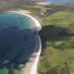
Eday, Doomy


Cairn (Period Unassigned), Hut Circle (Prehistoric)(Possible), Marker Cairn (Period Unassigned), Mound (Period Unassigned), Settlement (Period Unassigned)(Possible)
Site Name Eday, Doomy
Classification Cairn (Period Unassigned), Hut Circle (Prehistoric)(Possible), Marker Cairn (Period Unassigned), Mound (Period Unassigned), Settlement (Period Unassigned)(Possible)
Canmore ID 3209
Site Number HY53SE 4
NGR HY 5569 3450
NGR Description From HY 5569 3450 to HY 5565 3448
Datum OSGB36 - NGR
Permalink http://canmore.org.uk/site/3209


- Council Orkney Islands
- Parish Eday
- Former Region Orkney Islands Area
- Former District Orkney
- Former County Orkney
HY53SE 4 5569 3450 to 5565 3448.
What may be the remains of a ruinous chambered cairn lie on the promontory (HY 557 345) at the N end of the Loch of Doomy.
Nineteen large slabs lie within an area 25' in diameter, a number of them, over 3' long, near the centre. No definite structural arrangement is recognisable.
There is now no very distinct trace of a mound as such but the stones, some protruding on end to nearly 2' in height, seem to indicate that a structure of some kind formerly existed here. (Information from RCAHMS Mss notes). (Miss Henshall does not include this in her list of chambered cairns.)
RCAHMS 1946, visited 1928; A S Henshall 1963.
Not located. RCAHMS may be referring to one of the "cairns" published on OS 6" at HY 556 345, which are probably collapsed sea marker cairns.
Visited by OS(RL) 24 July 1970.
The site described by RCAMS is at 5565 3448. It is a confusion of erect earthfast slabs covering an approximately circular area and much more suggestive of a Bronze Age House than a chambered tomb.
At 5569 3450 is a round mound on a slight summit, under a navigation cairn. On its SW side are 3 earthfast erect slabs forming an L-plan.
The mound is 7m diameter, 0.4m high and probably contains another house. Protruding from peat to N of this mound across a hollow and on an alignment heading N-S towards the mound is the foundation of a drystone field wall, undoubtable ancient.
Visited by R G Lamb October 1981.
On the crest of a peat-covered headland RCAMS described as a slab-setting which was interpreted as a chambered cairn and scheduled as such (HY 5565 3448). It is a confusion of erect slabs covering an approximately circular but ill-defined area and may also be interpreted as a Bronze Age house. At HY 5568 3450, on a summit below a collapsed cairn, is a round mound 7m in diameter and 0.4m high with three erect slabs forming an L-shape on its SW side, and probably containing another house.
Protruding from peat and running N from this mound for some 30m is a sub-peat dyke.
Visited October 1981.
N Nayling 1983; RCAHMS 1984.
Field Visit (8 May 2013)
These two small stony structures are situated in open heather moorland close to the highest point of the Doomy peninsula. The more easterly (HS 55673 34507), sited on a low rise, is a heather- and grass-grown stone-and-boulder cairn measuring 9m in diameter by 0.35m in height and surmounted by a small marker cairn that has been quarried from its make-up. Its neighbour (HY 55636 34509), which is situated about 35m due W and at a slightly lower elevation, appears to be a damaged hut-circle. It measures 9m in diameter over a heather-grown wall of boulders, stones and slabs 0.3m in height. There is an entrance on the E that was originally lined with stones set on edge, but only three of these now remain in place - two on the N being upright while a third on the S has fallen. In addition, two outer facing-stones are visible.
The location and character of the structures on the Doomy peninsula has been a matter of some confusion in the past. The 1st and 2nd editions of the Ordnance Survey 6-inch map show two ‘cairns’ close to the highest point of the peninsula (HY 55673 34507 and HY 55636 34509) and as these were not considered to be antiquities, a modern rather than an Old English script was employed for the legend denoting them (Orkney 1882 and 1903, Sheet LXXXVI). In addition, they also show a much larger mound (HY 55589 34552) to their NW, sited about 20m from the cliff edge and measuring roughly 26m from N to SE by 22m transversely. The Name Book does not refer to any of these features, but in 1928 RCAHMS identified one of the structures (evidently the hut-circle) as a possible chambered cairn (RCAHMS 1946, 60). However, they did not locate it closely and a decade before the report and inventory of the monuments on Eday was published with its list of sites recommended for legal protection, the largest of the three mounds was scheduled by the Commissioners of HM Works presumably on the basis of a more informal report (Ancient Monument Certificate of Service of Notice 1936). Clearly, the Commissioners were guilty of equating size with importance having been misled by its dramatic representation on the maps. In practice, there is no trace of a large mound at the specified location and indeed, there are no grounds other than its appearance on the maps for the supposition that it ever existed. How it came to be delineated in the first place is unknown and perhaps likely to remain so.
Visited by RCAHMS (ATW) 8 May 2013.

