
Pricing Change
New pricing for orders of material from this site will come into place shortly. Charges for supply of digital images, digitisation on demand, prints and licensing will be altered.
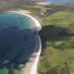
Eday, Sands Of Doomy


Mound (Period Unassigned), Natural Feature (Period Unknown)
Site Name Eday, Sands Of Doomy
Classification Mound (Period Unassigned), Natural Feature (Period Unknown)
Canmore ID 3205
Site Number HY53SE 18
NGR HY 5566 3377
Datum OSGB36 - NGR
Permalink http://canmore.org.uk/site/3205


- Council Orkney Islands
- Parish Eday
- Former Region Orkney Islands Area
- Former District Orkney
- Former County Orkney
HY53SE 18 5566 3377.
HY 5566 3377 - A mound c.20.0 m diameter, locally thought to be prehistoric, appearing to be a sand dune with a covering of peat. On the hill slopes around Loch of Doomy are many small mounds averaging about six metres in diameter. Several cut through by trenching around the new airstrip to the E of the loch, can be seen to be sandy knolls with a peat covering.
Visited OS(AA) 26 July 1970.
In 1970 the OS reported a mound, some 20m in diameter, locally thought to be ancient, on the hill slope S of London Airport (Eday). This appeared to be a sand dune with a covering of peat, as did several of the smaller mounds, many of which occur on this hillside, cut through by ditching in connection with the newly-created airstrip. As this heather land is earmarked for agriculture reclamation, two of these small mounds were dug into in 1982 and shown to be of natural origin.
Visited September 1982.
RCAHMS 1984.
Orkney Smr Note (September 1982)
This land is in line for reclamation. Two of these small
mounds were dug into with a spade to see what they are made of,
they turn out to be pure sand overlain by peat.
Mrs A Sargent, P Mason, & RGL Sep 82.

