
Following the launch of trove.scot in February 2025 we are now planning the retiral of some of our webservices. Canmore will be switched off on 24th June 2025. Information about the closure can be found on the HES website: Retiral of HES web services | Historic Environment Scotland
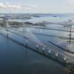
Queensferry Crossing


Road Bridge (21st Century)
Site Name Queensferry Crossing
Classification Road Bridge (21st Century)
Alternative Name(s) New Forth Road Bridge
Canmore ID 320250
Site Number NT17NW 316
NGR NT 1201 7998
Datum OSGB36 - NGR
Permalink http://canmore.org.uk/site/320250
Ordnance Survey licence number AC0000807262. All rights reserved.
Canmore Disclaimer.
© Bluesky International Limited 2025. Public Sector Viewing Terms
- Correction
- Favourite

DP 049584
Oblique aerial view of drilling works in advance of construction of Queensferry Crossing.
RCAHMS Aerial Photography Digital
11/6/2008
© Crown Copyright: HES

DP 049593
Oblique aerial view of drilling works in advance of construction of Queensferry Crossing.
RCAHMS Aerial Photography Digital
11/6/2008
© Crown Copyright: HES

DP 134889
Oblique aerial view of the new Forth crossing works site centred on a caisson and barge, taken from the S.
RCAHMS Aerial Photography Digital
1/6/2012
© Crown Copyright: HES

DP 134901
General oblique aerial view of the new Forth crossing works site, taken from the S.
RCAHMS Aerial Photography Digital
1/6/2012
© Crown Copyright: HES

DP 134904
General oblique aerial view of the new Forth crossing works site, taken from the SE.
RCAHMS Aerial Photography Digital
1/6/2012
© Crown Copyright: HES

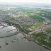
DP 142799
General oblique aerial view of Kirkliston, Queensferry Crossing Access Works, looking NW.
RCAHMS Aerial Photography Digital
20/5/2012
© Crown Copyright: HES

DP 153396
Oblique aerial view during construction of the New Forth Bridge Crossing, looking to the S.
RCAHMS Aerial Photography Digital
1/5/2013
© Crown Copyright: HES

DP 154317
General oblique aerial view of the River Forth centred on the new Forth Bridge crossing, looking to the ESE.
RCAHMS Aerial Photography Digital
10/5/2013
© Crown Copyright: HES

DP 154339
General oblique aerial view of the River Forth centred on the construction of the new Forth Bridge crossing, looking to the N.
RCAHMS Aerial Photography Digital
10/5/2013
© Crown Copyright: HES

DP 163423
Oblique aerial view of the bridge supports under construction, looking NE.
RCAHMS Aerial Photography Digital
4/8/2013
© Crown Copyright: HES

DP 163424
Oblique aerial view of the bridge supports under construction, looking WNW.
RCAHMS Aerial Photography Digital
4/8/2013
© Crown Copyright: HES

DP 163425
Oblique aerial view of the bridge supports under construction, looking WNW.
RCAHMS Aerial Photography Digital
4/8/2013
© Crown Copyright: HES

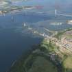
DP 164369
Oblique aerial view of the new Queensferry Crossing construction site centred on a caisson and barges, looking to the NE.
RCAHMS Aerial Photography Digital
29/10/2013
© Crown Copyright: HES

DP 164395
Oblique aerial view of the new Queensferry Crossing construction site at South Queensferry, looking to the NNE.
RCAHMS Aerial Photography Digital
29/10/2013
© Crown Copyright: HES

DP 175597
Oblique aerial view of the construction of the new Queensferry crossing, looking N.
RCAHMS Aerial Photography Digital
3/3/2014
© Crown Copyright: HES

DP 176063
Oblique aerial view of the construction of the Queensferry Crossing, the Forth Road Bridge and Forth Rail Bridge, looking SSE.
RCAHMS Aerial Photography Digital
7/2/2014
© Crown Copyright: HES

DP 188494
Oblique aerial view of the Forth Bridge, Forth Road Bridge and construction of the Queensferry Crossing, looking NE.
RCAHMS Aerial Photography Digital
2/5/2014
© Crown Copyright: HES

DP 188496
Oblique aerial view of the construction of the Queensferry Crossing on the south bank of the River Forth, looking WSW.
RCAHMS Aerial Photography Digital
2/5/2014
© Crown Copyright: HES

DP 189688
Oblique aerial view of the construction of the new Queensferry Crossing on the south bank of the Forth, looking N.
RCAHMS Aerial Photography Digital
21/5/2014
© Crown Copyright: HES

DP 189691
Oblique aerial view of the construction of the new Queensferry Crossing and Port Edgar, looking SE.
RCAHMS Aerial Photography Digital
21/5/2014
© Crown Copyright: HES

DP 189692
Oblique aerial view of the roadworks for the new Queensferry Crossing on the south bank of the Forth, looking NW.
RCAHMS Aerial Photography Digital
21/5/2014
© Crown Copyright: HES

DP 190595
Forth crossing under construction. View of south deck and supports from road bridge to north east
Records of the Royal Commission on the Ancient and Historical Monuments of Scotland (RCAHMS), Edinbu
5/5/2014
© Crown Copyright: HES

DP 190600
Forth crossing under construction. View of support pillar with crane and barge from road bridge to east
Records of the Royal Commission on the Ancient and Historical Monuments of Scotland (RCAHMS), Edinbu
5/5/2014
© Crown Copyright: HES

DP 191324
General oblique aerial view of the Upper Firth of Forth with The Queensferry Crossing construction, Forth Road bridge and Forth bridge in the distance, looking NE.
RCAHMS Aerial Photography Digital
16/6/2014
© Crown Copyright: HES

DP 191327
Oblique aerial view of the construction of the new Queensferry Crossing, the Forth Road Bridge and South Queensferry, looking NNW.
RCAHMS Aerial Photography Digital
16/6/2014
© Crown Copyright: HES

DP 191328
Oblique aerial view of the construction of the Queensferry Crossing, looking SW.
RCAHMS Aerial Photography Digital
16/6/2014
© Crown Copyright: HES

DP 191335
Oblique aerial view of the construction of the Queensferry Crossing, looking NNW.
RCAHMS Aerial Photography Digital
16/6/2014
© Crown Copyright: HES

DP 192989
Oblique aerial view of the roadworks on the north bank of the River Forth leading to the Queensferry Crossing, looking NNE.
RCAHMS Aerial Photography Digital
11/7/2014
© Crown Copyright: HES

DP 193005
Oblique aerial view of the roadworks on the north bank of the River Forth leading to the Queensferry Crossing, looking ENE.
RCAHMS Aerial Photography Digital
11/7/2014
© Crown Copyright: HES

DP 193040
Oblique aerial view of the construction of the Queensferry Crossing and Port Edgar, looking E.
RCAHMS Aerial Photography Digital
11/7/2014
© Crown Copyright: HES

DP 201161
Oblique aerial view of the construction of central tower for the Queensferry Crossing, looking NE.
RCAHMS Aerial Photography Digital
5/11/2014
© Crown Copyright: HES

DP 205369
South, mid and north towers under construction, view ofrom road bridge to south
Records of the Royal Commission on the Ancient and Historical Monuments of Scotland (RCAHMS), Edinbu
28/12/2014
© Crown Copyright: HES

DP 205378
South end of bridge deck under construction with Port Edgar marina in foreground
Records of the Royal Commission on the Ancient and Historical Monuments of Scotland (RCAHMS), Edinbu
28/12/2014
© Crown Copyright: HES

DP 205385
Mid tower under construction, view from road bridge to east
Records of the Royal Commission on the Ancient and Historical Monuments of Scotland (RCAHMS), Edinbu
28/12/2014
© Crown Copyright: HES

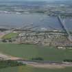
DP 209192
Oblique aerial view of the construction works for the approach to the Queensferry Crossing on the N bank, looking ESE.
RCAHMS Aerial Photography Digital
2/12/2014
© Crown Copyright: HES

DP 209193
Oblique aerial view of the construction works for the approach to the Queensferry Crossing on the N bank, looking E.
RCAHMS Aerial Photography Digital
2/12/2014
© Crown Copyright: HES

DP 211159
Oblique aerial view of the construction of the Queensferry Crossing on the south bank of the River Forth, looking SE.
RCAHMS Aerial Photography Digital
4/3/2015
© Crown Copyright: HES

DP 211177
Oblique aerial view of the construction of a tower for the Queensferry Crossing, looking W.
RCAHMS Aerial Photography Digital
4/3/2015
© Crown Copyright: HES

DP 214017
Oblique aerial view of the construction of the approach on the north bank of the Queensferry Crossing, looking SSE.
RCAHMS Aerial Photography Digital
25/3/2015
© Crown Copyright: HES

DP 215589
Oblique aerial view of the roadworks on the north bank of the River Forth on the approach to the Queensferry Crossing, looking ESE.
RCAHMS Aerial Photography Digital
3/7/2015
© Crown Copyright: HES

DP 215592
Oblique aerial view of the construction of the north tower of the Queensferry Crossing, looking NE.
RCAHMS Aerial Photography Digital
3/7/2015
© Crown Copyright: HES

DP 215603
Oblique aerial view of the construction of the Queensferry Crossing, looking SSW.
RCAHMS Aerial Photography Digital
3/7/2015
© Crown Copyright: HES

DP 215623
Oblique aerial view of the construction of the Queensferry Crossing, looking NNW.
RCAHMS Aerial Photography Digital
3/7/2015
© Crown Copyright: HES

DP 217620
Deck at south end of crossing, view from road bridge to east
Records of the Royal Commission on the Ancient and Historical Monuments of Scotland (RCAHMS), Edinbu
12/7/2015
© Crown Copyright: HES

DP 217637
North tower and pillars at north end of crossing, view from road bridge to south east
Records of the Royal Commission on the Ancient and Historical Monuments of Scotland (RCAHMS), Edinbu
12/7/2015
© Crown Copyright: HES

DP 217664
Port Edgar marina, view from road bridge to north east
Records of the Royal Commission on the Ancient and Historical Monuments of Scotland (RCAHMS), Edinbu
12/7/2015
© Crown Copyright: HES

DP 217666
Port Edgar marina, view from road bridge to east
Records of the Royal Commission on the Ancient and Historical Monuments of Scotland (RCAHMS), Edinbu
12/7/2015
© Crown Copyright: HES

DP 217669
Boat repair yard at south end of crossing, view from road bridge to north east
Records of the Royal Commission on the Ancient and Historical Monuments of Scotland (RCAHMS), Edinbu
12/7/2015
© Crown Copyright: HES

DP 220939
Oblique aerial view of the construction of the Queensferry Crossing at the north bank, looking WSW.
RCAHMS Aerial Photography Digital
11/9/2015
© Crown Copyright: HES

DP 220945
Oblique aerial view of the north tower during the construction of the Queensferry Crossing, looking N.
RCAHMS Aerial Photography Digital
11/9/2015
© Crown Copyright: HES

DP 220947
Oblique aerial view of the north tower during the construction of the Queensferry Crossing, looking W.
RCAHMS Aerial Photography Digital
11/9/2015
© Crown Copyright: HES

DP 220950
Oblique aerial view of the construction of the Queensferry Crossing at the north bank, looking NE.
RCAHMS Aerial Photography Digital
11/9/2015
© Crown Copyright: HES

DP 220954
Oblique aerial view of the north tower during the construction of the Queensferry Crossing, looking WNW.
RCAHMS Aerial Photography Digital
11/9/2015
© Crown Copyright: HES

DP 229873
Oblique aerial view of the construction of Queensferry Crossing, looking S.
Historic Environment Scotland
10/2/2016
© Crown Copyright: HES

DP 229875
Oblique aerial view of the construction of Queensferry Crossing, looking ESE.
Historic Environment Scotland
10/2/2016
© Crown Copyright: HES

DP 229882
Oblique aerial view of the south tower of the Queensferry Crossing, looking ESE.
Historic Environment Scotland
10/2/2016
© Crown Copyright: HES

DP 229893
Oblique aerial view of the central tower of the Queensferry Crossing, looking NNW.
Historic Environment Scotland
10/2/2016
© Crown Copyright: HES

DP 229904
Oblique aerial view of the north tower of the Queensferry Crossing, looking SW.
Historic Environment Scotland
10/2/2016
© Crown Copyright: HES

DP 229905
Oblique aerial view of the north tower of the Queensferry Crossing, looking S.
Historic Environment Scotland
10/2/2016
© Crown Copyright: HES

DP 229911
Oblique aerial view of the north tower of the Queensferry Crossing, looking ESE.
Historic Environment Scotland
10/2/2016
© Crown Copyright: HES

DP 229914
Oblique aerial view of the north tower of the Queensferry Crossing, looking E.
Historic Environment Scotland
10/2/2016
© Crown Copyright: HES

DP 229917
Oblique aerial view of the central tower of the Queensferry Crossing, looking WNW.
Historic Environment Scotland
10/2/2016
© Crown Copyright: HES

DP 233128
Oblique aerial view of the road works on the north bank of the River Forth during the construction of the Queensferry Crossing, looking E.
Historic Environment Scotland
27/4/2016
© Crown Copyright: HES

DP 233131
Oblique aerial view of the construction of the Queensferry Crosssing at the north bank of the River Forth, looking NNE.
Historic Environment Scotland
27/4/2016
© Crown Copyright: HES

DP 233147
Oblique aerial view of the construction of the north span of the Queensferry Crossing, looking SW.
Historic Environment Scotland
27/4/2016
© Crown Copyright: HES

DP 233149
Oblique aerial view of the construction of the Queensferry Crosssing at the south bank of the River Forth, looking SE.
Historic Environment Scotland
27/4/2016
© Crown Copyright: HES

DP 237805
Oblique aerial view.
Historic Environment Scotland
14/7/2016
© Copyright: HES

DP 241575
Oblique aerial view.
Historic Environment Scotland
15/8/2016
© Copyright: HES

DP 246257
Mid and north towers, view from road bridge to south east
Records of the Royal Commission on the Ancient and Historical Monuments of Scotland (RCAHMS), Edinbu
22/11/2016
© Copyright: HES

DP 246259
Deck at south end of crossing and south tower, view from road bridge to south east
Records of the Royal Commission on the Ancient and Historical Monuments of Scotland (RCAHMS), Edinbu
22/11/2016
© Copyright: HES

DP 246268
Mid tower, view from road bridge to south east
Records of the Royal Commission on the Ancient and Historical Monuments of Scotland (RCAHMS), Edinbu
22/11/2016
© Copyright: HES

DP 246273
North tower, deck section and pillars at north end of crossing, view from road bridge to south east
Records of the Royal Commission on the Ancient and Historical Monuments of Scotland (RCAHMS), Edinbu
22/11/2016
© Copyright: HES

DP 246283
North tower, deck section, view from road bridge to south east
Records of the Royal Commission on the Ancient and Historical Monuments of Scotland (RCAHMS), Edinbu
22/11/2016
© Copyright: HES

DP 246291
North, mid and south towers, general view from road bridge to north east
Records of the Royal Commission on the Ancient and Historical Monuments of Scotland (RCAHMS), Edinbu
22/11/2016
© Copyright: HES

DP 246299
Deck at south end of crossing, view from road bridge to north east
Records of the Royal Commission on the Ancient and Historical Monuments of Scotland (RCAHMS), Edinbu
22/11/2016
© Copyright: HES

DP 246304
South tower, view from road bridge to south east
Records of the Royal Commission on the Ancient and Historical Monuments of Scotland (RCAHMS), Edinbu
22/11/2016
© Copyright: HES

DP 246305
South tower, view from road bridge to south east
Records of the Royal Commission on the Ancient and Historical Monuments of Scotland (RCAHMS), Edinbu
22/11/2016
© Copyright: HES

DP 246368
Oblique aerial view.
Historic Environment Scotland
5/1/2017
© Copyright: HES

DP 246374
Oblique aerial view.
Historic Environment Scotland
5/1/2017
© Copyright: HES

DP 246417
South and mid towers, view from road bridge to north east
Records of the Royal Commission on the Ancient and Historical Monuments of Scotland (RCAHMS), Edinbu
28/2/2016
© Copyright: HES

DP 246420
Mid tower, detail of deck and lower section of tower
Records of the Royal Commission on the Ancient and Historical Monuments of Scotland (RCAHMS), Edinbu
28/2/2016
© Copyright: HES

DP 246430
South tower, view from road bridge to south east
Records of the Royal Commission on the Ancient and Historical Monuments of Scotland (RCAHMS), Edinbu
28/2/2016
© Copyright: HES

DP 246461
Mid tower, view from road bridge to south east
Records of the Royal Commission on the Ancient and Historical Monuments of Scotland (RCAHMS), Edinbu
31/7/2016
© Copyright: HES

DP 246462
South approach to crossing, view from road bridge to north east
Records of the Royal Commission on the Ancient and Historical Monuments of Scotland (RCAHMS), Edinbu
31/7/2016
© Copyright: HES

DP 246464
Mid tower, view from road bridge to south east
Records of the Royal Commission on the Ancient and Historical Monuments of Scotland (RCAHMS), Edinbu
31/7/2016
© Copyright: HES

DP 246471
Mid tower, upper section, cables and crane, view from road bridge to east
Records of the Royal Commission on the Ancient and Historical Monuments of Scotland (RCAHMS), Edinbu
31/7/2016
© Copyright: HES

DP 246489
North tower, view from road bridge to north east
Records of the Royal Commission on the Ancient and Historical Monuments of Scotland (RCAHMS), Edinbu
31/7/2016
© Copyright: HES

DP 247247
Oblique aerial view.
Historic Environment Scotland
26/1/2017
© Crown Copyright: HES

DP 247253
Oblique aerial view.
Historic Environment Scotland
26/1/2017
© Crown Copyright: HES

DP 247255
Oblique aerial view.
Historic Environment Scotland
26/1/2017
© Crown Copyright: HES

DP 247276
Oblique aerial view.
Historic Environment Scotland
26/1/2017
© Crown Copyright: HES

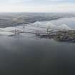
DP 264790
Oblique aerial view of the Queensferry Crossing on the day of the public pedestrian crossing.
Historic Environment Scotland
2/9/2017
© Crown Copyright: HES

DP 264794
Oblique aerial view of the Queensferry Crossing on the day of the public pedestrian crossing.
Historic Environment Scotland
2/9/2017
© Crown Copyright: HES

DP 264798
Oblique aerial view of the Queensferry Crossing on the day of the public pedestrian crossing.
Historic Environment Scotland
2/9/2017
© Crown Copyright: HES

DP 264802
Oblique aerial view of the Queensferry Crossing on the day of the public pedestrian crossing.
Historic Environment Scotland
2/9/2017
© Crown Copyright: HES

DP 264813
Oblique aerial view of the Queensferry Crossing on the day of the public pedestrian crossing.
Historic Environment Scotland
2/9/2017
© Crown Copyright: HES

DP 264820
Oblique aerial view of the Queensferry Crossing on the day of the public pedestrian crossing, taken in 2016.
Historic Environment Scotland
2/9/2017
© Crown Copyright: HES

DP 265489
Oblique aerial view.
Historic Environment Scotland
11/9/2017
© Crown Copyright: HES

DP 265504
Oblique aerial view.
Historic Environment Scotland
11/9/2017
© Crown Copyright: HES

DP 265509
Oblique aerial view.
Historic Environment Scotland
11/9/2017
© Crown Copyright: HES


First 100 images shown. See the Collections panel (below) for a link to all digital images.
- Council Fife
- Parish Inverkeithing
- Former Region Fife
- Former District Dunfermline
- Former County Fife
Photographic Survey (2014 - 2017)
The Forth Replacement Crossing and particularly the Queensferry Crossing Bridge have been photographed by HES Survey and Recording (Architecture and Industry) during 2014 until 2017.
Information from HES Survey and Recording (Architecture and Industry) MMD, 13 January 2017.
Note (1 January 2017)
This new road bridge is due for completion May 2017 and is between Fife and Edinburgh. This cable-stayed bridge has three single column towers, is 2.7km in length and will contain 42,000 tonnes of steel. It will be 'the longest three tower cable-stayed bridge in the world' and the tallest bridge in the UK when completed. It will contain 23,000 miles of cabling The entire infrastructure scheme Forth Replacement Crossing or FRC) will have a 13.7 mile (22km) footprint.
Information from http://www.transport.gov.scot/project/forth-replacement-crossing/about-frc-project#about the bridge (retrieved: 13 01 2017)
Public Site Comment
Working as a Steward on Inchcolm Island the last two years I saw the last parts of the pieces being added to the new crossing and this year its opening.

