
Balgarthno Stone Circle


Rig And Furrow (Post Medieval), Stone Circle (Neolithic) - (Bronze Age)
Site Name Balgarthno Stone Circle
Classification Rig And Furrow (Post Medieval), Stone Circle (Neolithic) - (Bronze Age)
Alternative Name(s) Liff Railway Station; The Nine Stanes Of Invergowrie; Gourdie, Stone Circle 850m S Of; Myrekirk; The Devil's Stones
Canmore ID 31955
Site Number NO33SE 5
NGR NO 35330 31613
NGR Description centred
Datum OSGB36 - NGR
Permalink http://canmore.org.uk/site/31955


- Council Dundee, City Of
- Parish Dundee (Dundee, City Of)
- Former Region Tayside
- Former District City Of Dundee
- Former County Angus
NO33SE 5 3533 3161.
(NO 3533 3161) Druidical Temple (NR) (Remains of) Stone Circle (NR)
OS 6" map, (1960)
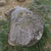
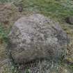
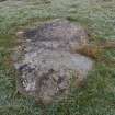
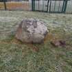
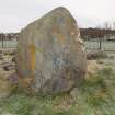
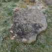
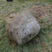
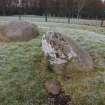
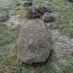
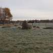
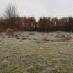
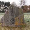
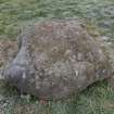
This stone circle, about 20' in diameter, consists of nine large boulders, all fallen, except the western-most which stands about 6' high. Warden (1880-5) recorded four smaller stones and a trench, 40 yds in circumference, which surrounded the stone circle. Jervise (1859), who "had the place searched" in the spring of 1856, found nothing significant.
Name Book 1858; A Jervise 1859; A J Warden 1880-5.
NO 3533 3160. The nine stones forming this circle are as described above. The upright stone is 1.6m long x 0.7m wide x 1.5m high; the others are recumbent and were probably never erect. They are now hidden by rank grass and several field cleared stones lie within the circle. None of the stones is scupltured and all are greatly weathered. There are no traces of ditch, bank, or inner mound. The site appears to have been undisturbed for years.
Resurveyed at 1:2500.
Visited by OS (W D J) 19 October 1965.
NO 3533 3161 An archaeological watching brief was carried out during the excavation of post holes for a security fence around the stone circle. The 9 stones remains, although are heavily damaged by weathering and vandalism. In total 26 pits were excavated. A field drain was found at the bottom of one pit. Nothing of archaeological interest was found. Whilst it is clear that the site is of undisputed antiquity, there was very little, if any, evidence of activity around the stones. This may have resulted from the site having been investigated in the mid 19th-century, possibly resulting in the destruction of any meaningful stratigraphy; the protracted length of time it has remained within a park setting or, finally, the minimal nature of the disturbance not being sufficient to reveal any meaningful results.
D Hind 2006
Antiquarian Observation (1856)
Jervise (1859), who "had the place searched" in the spring of 1856, found nothing significant.
Watching Brief (19 December 2005)
A watching brief was conducted in December 2005 on the excavation of postholes for a security fence surrounding Balgarthno Stone Circle. No finds of antiquity were noted.
McManus Galleries commissioned SUAT Ltd to undertake an archaeological watching brief at Balgarthno Stone Circle, Dundee, on the excavation of post-holes related to the construction of a security fence around the monument. The work was centred upon NGR NO 3533 3161. The work (SUAT site code DD49) was undertaken on 19th December 2005 in good weather conditions. The requirement was to monitor the excavation of post-holes, to record soil depth and recover any artefacts.
The work was designed to satisfy the Scheduled Monument consent required for the works.
All excavations were archaeologically monitored for evidence of stratigraphy and for artefacts. In total 26 pits were excavated, with no major differences in stratigraphy noted. Two distinct layers were noted in 25 pits - a dark brown loam… approximately 150mm thick, which covered a dark brick-red degraded sandstone subsoil…
At the bottom of one pit… a field drain, aligned NNE-SSW, was noted. This appeared to have been cut into the subsoil, and was found at approximately 500mm depth. The backfill to the field drain… appeared to be identical in nature to the topsoil, although a separate number was assigned to it.
Information from Dundee SMR
Publication Account (2011)
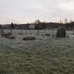
This stone circle, which is situated in a park on the west side of Dundee, comprises a ring of nine stones with an internal diameter of about 8m. With the exception of one upright orthostat standing 1.5m high on the west, all the stones have fallen. Other boulders lying within the circle are probably field clearance gathered when the surrounding ground was under cultivation. The report on a watching brief carried out here on behalf of the McManus Galleries, Dundee, refers to the ring as a recumbent stone circle, apparently citing this as one of the reasons that the monument was initially scheduled in 1935 (Hind 2006, 1). While clearly a circle of largely recumbent stones, the circle shares no architectural characteristics with the type of monument known as a recumbent stone circle. Its affinities lie with a group of small rings found elsewhere across Angus and Perthshire (eg RCAHMS 1994, 30–3).
Field Visit (19 November 2019)
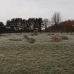
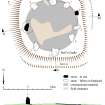
This stone circle is situated on the crest of a low W facing ridge and now stands isolated in an octagonal fenced enclosure within a public park. Formerly, the ground belonged to the arable fields of Balgarthno Farm, which is depicted on the 1st edition of the OS 25-inch map some 550m to the WSW, but has since been demolished and removed (Forfarshire 1865, sheet LIII.7). Ploughing over the years has left a deep scar around the circle such that today it occupies a square platform 17m across and raised up to 0.3m above the surrounding ground surface. Beyond the fenced enclosure, there are traces of rig and furrow cultivation. The rigs, which are 3m in breadth and 0.1m high, are aligned E and W. Furrows of this rig system within the enclosure have deepened the scar to the N and S of the ring. Circular on plan, this monument measures 9m in diameter and comprises 9 rather lumpen, weathered stones that may all have originated as local erratics. Only the orthostat on the W (1), measuring 1.52m high, 1.66m broad and 0.85m thick remains fully upright, but it is cracked and missing small pieces. However, a second orthostat on the ENE (6), now leaning sharply westward, still retains a tenuous footing, while the remainder lie prone. Measurements of the individual orthostats suggest the possibility that they were once graded in height with the tallest on the S (3) (measuring 1.98m though now fallen) and the shortest on the ENE (6) (measuring 0.69m high), but this cannot now be confirmed. The two standing orthostats are embedded at the edge of a grass-grown cairn, with the fallen orthostats lying at roughly appropriate intervals. There is a scatter of field clearance on the cairn’s surface.
Balgarthno stone circle has been known since at least the end of the 18th century, when the Reverend Thomas Constable referred to it as ‘a temple, called Druidical, measuring in circumference about 43 yards’ (12.5m diameter) (Stat Acct, xiii, 1794, 115). Unfortunately, almost fifty years later, the Reverend George Addison, his successor as minister of Liff and Bervie, seems to have confused his imperial units, mistakenly reporting the space it enclosed as about ‘ten feet in diameter’ (NSA, xi, Forfarshire, 579). Neither of these authorities gives any indication as to the ring’s condition, but despite a hint to the contrary from Gersham Cumming, who described it as ‘entire’ (Cumming 1848, 2), it is clear from Andrew Jervise’s characterisation of it as ‘a Druidical circle consisting of nine stones, one of which only stands upright’, that it had all but reached its present state of dilapidation by 1856 (Jervise 1859, 443). In the spring of that year and with the permission of the landowner, Alexander Clayhills of Invergowrie, Jervise supervised an exploratory excavation on behalf of John Stuart, who was then completing the first volume of ‘Sculptured Stones of Scotland’ (Stuart 1856, I, xxiii). Jervise had his workmen make ‘a digging . . . about each stone . . . without the discovery of any deposit’ (Stuart 1856, I, xxiii). Indeed, he declared that he had ‘found nothing of moment’ (Jervise 1859, 443). The site was plotted by the Ordnance survey four years later and the 1st edition of the OS 25-inch map shows that cultivation had already raised it above the general level of the field (Forfarshire 1865, sheet LIII.7). While describing the ring, as ‘perfect’, the Surveyors also reported that the landowner had inserted a clause in the lease that forbade the tenant from destroying or removing the stones (Name Book, Angus, No.61, p 51). How much damage had been caused by Jervise’s excavation is unknown, but Alexander Warden later described the circle as ‘formed of nine large and four smaller stones’ all ‘surrounded by a small trench’ (Warden 1884). The character of these additional stones is unknown, but the ‘trench’ evidently resulted from the field’s persistent cultivation. The ring was described as a conspicuous landmark by Alexander Elliot in 1911, who ornamented his account with a vivid overlay of Druidical lore and also provided a small sketch taken from the NW by the poet and journalist Joseph Lee (Elliot 1911). The monument was scheduled in 1935, when it was apparently identified as a recumbent stone circle and the most southerly of this class (Hind 2006b). However, there is nothing in the documentation held at the National Archives of Scotland to confirm this (NAS: DD27/2206). Part of a jet ring (NMS X.EP 188) and a fine flint scraper (NMS X.EP 189) were discovered by Daniel Henderson ‘at the stone circle’ in 1963-4, when its immediate hinterland was still under intensive cultivation (Anon 1964, 255; Burl 1976, 354; Burl 2000, 423). The precise circumstances are unclear, but Henderson was evidently a keen field walker (cf. Longworth et al 1967) and presented other prehistoric finds from the farm to the museum. Persistent vandalism and a wish to both protect and call attention to the historical significance of the stone circle led the McManus Galleries, Dundee, to fund a watching brief in 2005 before the erection of the present security fence (Hind 2006a). Twenty-five of the twenty-six fence post sockets that were examined by Damian Hind disclosed only a dark brown loam (0.15m thick) overlying a dark brick red soil of degraded sandstone (Hind 2006b). By contrast, the twenty-sixth revealed a field drain at its base. Since then, the ‘Friends of Balgarthno’ have adopted the monument and planted wild flowers within the interior to offset the visual impact of the fence (Ritchie 2008; Bradley 2008), while Darren Eyers has produced an interactive 3D model with the aid of the software Sketchfab (Eyers 2015).
Balgarthno has affinities with the group of small rings found in Angus and Perthshire. These are very poorly dated, but are likely to date to the Bronze Age (RCAHMS 1994; Welfare 2011).
Visited by HES, Survey and Recording (ATW, AMcC) 19 November 2019
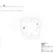
Measured Survey (19 November 2019)
HES surveyed Balgarthno stone circle with plane-table and alidade on 19 November 2019 at a scale of 1:100. GNSS data was also collected to record survey control and sections across the site. The resultant plan and sections were redrawn in vector graphics software.
Conservation
NO 3533 3161 The Friends of Balgarthno Stones together with two local primary schools (St Clement’s and
Charleston) have adopted this stone circle in Charleston housing estate, Dundee. The site (consisting of nine large boulders, all fallen with the exception of the westernmost) is surrounded by a protective fence erected in 2006. This summer scheduled monument consent was applied for to plant a low wildflower meadow consisting of local native species. This was intended to offset the visual impact of the fence surrounding the stones and enhance the setting of the monument, while raising awareness of the site and boosting local biodiversity. A rolling programme of education and outreach continues.
Funder: Awards for All
Mary Ritchie (Friends of Balgarthno Stone Circle), 2008

