
Dundee, King's Cross, Standard Stone


Cross Base (Early Medieval)
Site Name Dundee, King's Cross, Standard Stone
Classification Cross Base (Early Medieval)
Alternative Name(s) Camperdown House
Canmore ID 31916
Site Number NO33SE 14
NGR NO 3583 3292
Datum OSGB36 - NGR
Permalink http://canmore.org.uk/site/31916


- Council Dundee, City Of
- Parish Dundee (Dundee, City Of)
- Former Region Tayside
- Former District City Of Dundee
- Former County Angus
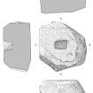
Camperdown House, King’s Cross, Dundee, cross base
Measurements: L 1.05m, W 0.95m, H 0.54m
Stone type: sandstone
Place of discovery: NO 3583 3292
Present location: 40m south-west of Camperdown House.
Evidence for discovery: in the mid nineteenth century this cross-base stood on a mound some 2.5m to the east and was known as ‘King’s Cross’ or ‘Standard Stone’. It was moved sometime after 1865.
Present condition: weathered.
Description
An irregularly shaped boulder, the top is dressed level and a rectangular socket is cut into it. The socket measures about 0.23m by 0.14m and 0.18 in depth.
Date range: early medieval.
Primary references: Borland, Fraser & Sherriff 2007, 101-3.
Desk-based information compiled by A Ritchie 2019
NO33SE 14 3583 3292
(NO 3583 3292) King's Cross (NR) (remains of)
OS 1:10,000 map, (1975).
See also NO33SE 31.
King's Cross: This stone, also known as the Standard Stone, is a rough-hewn boulder, c. 3 1/2' x 2' x 20", with a socket hole 9 1/2" x 6 1/2" x 8". It now stands on the lawn fronting Camperdown House (at NO 3588 3298). At one time (a century ago) the stone rested on the top of the larger of two tumuli (NO33SE 31) where it had probably been placed when the smaller tumulus was opened in 1787. It is unlikely that the stone was ever used as a base for the insertion of a standard pole - it would appear to be a cross-base.
H Macintosh 1939.
NO 3583 3292. This cross-base is as described.
Visited by OS (J L D)
This large sandstone boulder is situated 40m SW of Camperdown House, in parkland adjacent to the golf course that now occupies the W part of the former policies of the country house. The boulder measures 1.05m from N to S by 0.95m transversely and at least 0.54m in thickness; the rectangular socket, which is situated at the centre of the flat upper surface, measures about 230mm by 140mm, though its lip has been damaged and eroded, and 180mm in depth.
Visited by RCAHMS (JRS) February 2007.

