
Calf Knowe


Bank (Earthwork) (Post Medieval)
Site Name Calf Knowe
Classification Bank (Earthwork) (Post Medieval)
Alternative Name(s) Raeburnfoot
Canmore ID 318755
Site Number NY29NE 106
NGR NY 24995 99260
Datum OSGB36 - NGR
Permalink http://canmore.org.uk/site/318755


- Council Dumfries And Galloway
- Parish Eskdalemuir
- Former Region Dumfries And Galloway
- Former District Annandale And Eskdale
- Former County Dumfries-shire
Field Visit (1992)
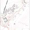
An area of relict field banks, on the SE facing slopes of Calf Knowe was mapped but not otherwise described, during the Eastern Dumfriesshire field survey.
Information from RCAHMS (PMcK) 23 July 2012

