
Pricing Change
New pricing for orders of material from this site will come into place shortly. Charges for supply of digital images, digitisation on demand, prints and licensing will be altered.
North Uist, Hanglam


Midden (Period Unassigned)
Site Name North Uist, Hanglam
Classification Midden (Period Unassigned)
Canmore ID 318571
Site Number NF76NW 45
NGR NF 71477 68135
Datum OSGB36 - NGR
Permalink http://canmore.org.uk/site/318571


- Council Western Isles
- Parish North Uist
- Former Region Western Isles Islands Area
- Former District Western Isles
- Former County Inverness-shire
Field Visit (31 May 2012)
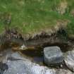
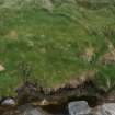
This midden can be seen eroding out of the face of a sand dune on the S coast of the Hanglam peninsula. It measures over 3m in length by 0.3m in thickness and comprises a rich dark soil containing limpets, periwinkles and fractured animal bones.
Visited by RCAHMS (AGCH, IP) 31 May 2012.

