
Pricing Change
New pricing for orders of material from this site will come into place shortly. Charges for supply of digital images, digitisation on demand, prints and licensing will be altered.
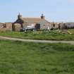
North Uist, Seanaval


Building(S) (Period Unassigned), Farmstead (Period Unassigned)
Site Name North Uist, Seanaval
Classification Building(S) (Period Unassigned), Farmstead (Period Unassigned)
Canmore ID 318499
Site Number NF77SW 166
NGR NF 72329 70089
Datum OSGB36 - NGR
Permalink http://canmore.org.uk/site/318499


- Council Western Isles
- Parish North Uist
- Former Region Western Isles Islands Area
- Former District Western Isles
- Former County Inverness-shire
Field Visit (12 September 2012)
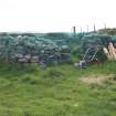
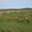
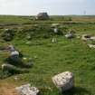
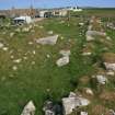
This farmstead, which stands on a natural rise and was occupied by the Balranald estate tacksman in the 19th century, comprises a row of three cottages on the N, a long range (largely reduced to footings) 25m to the SW, and a ruinous U-plan range open to the ENE some 35m to the SE. Neither of the first two mentioned structures, which are depicted roofed or partly roofed on both the first and second editions of the OS 25 inch map (Inverness-shire (Hebrides) 1881 and 1903, Sheet XXXIII.8), was noted in detail on the date of visit.
Of the buildings in the U-shaped range, the largest (NF 72329 70088) stands on the WSW and measures 16.6m from NNW to ESE by 5m transversely over walls 1.2m thick and 0.5m high which have rounded corners. There is an entrance (1.2m wide) at the NNW end of the ENE side and there are fragments of external harling at the SE corner. The interior contains two compartments separated by a thick partition wall that may have contained fireplaces. The building (NF 72343 70081) on the SSE side of the range measures about 10.4m from ENE to WSW by 4.7m transversely within low stone walls up to 1.2m in thickness. The interior contains three compartments, the W one appearing to have an entrance on the N. The building (NF 72331 70104) on the opposite side of the courtyard, which measures about 19m from ENE to WSW by 4.6m transversely within stone walls about 1.2m in thickness, has generally been reduced to its lowermost courses but its NE corner has been removed and the WSW compartment has been rebuilt to form a later store-room that survives to wall head height and has a blocked original entrance in its NNW side and a more recent one in its WSW end.
There is a local tradition which states that this steading was the site of the 18th century Balranald House, seat of the Macdonalds of Balranald, who, about 1830, constructed a farmhouse (NF76NW 8.01) and a steading (NF76NW 8.02) just over 400m to the SW (Miers 2008, 372). The old steading is depicted on an estate map of 1799 (RHP 1306) and in 1877 the Ordnance Survey noted that Seanaval was ‘an old farm house now occupied by farm servants’ and that ‘the whole is one storey, thatched, and in bad repair’ (Name Book 6, 146). The fact that some of the buildings of the steading are depicted roofed on both the 1st and 2nd editions of the OS 25 inch map probably indicates that despite a new steading being built the old one remained in at least partial use.
Visited by RCAHMS (GFG, IP) September 2012.
Measured Survey (12 September 2012 - 13 September 2012)
RCAHMS surveyed the tacksman’s house and farmstead at Seanaval between 12-13 September 2012 with plane-table and alidade producing a plan at a scale of 1:100.

