
Following the launch of trove.scot in February 2025 we are now planning the retiral of some of our webservices. Canmore will be switched off on 24th June 2025. Information about the closure can be found on the HES website: Retiral of HES web services | Historic Environment Scotland
North Uist, Goular


Township (19th Century)
Site Name North Uist, Goular
Classification Township (19th Century)
Canmore ID 318033
Site Number NF77SW 93
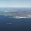
NGR NF 7062 7069
Datum OSGB36 - NGR
Permalink http://canmore.org.uk/site/318033


- Council Western Isles
- Parish North Uist
- Former Region Western Isles Islands Area
- Former District Western Isles
- Former County Inverness-shire
Note (22 May 2012)
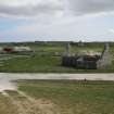
A group of five roofed buildings and one unroofed building are depicted on the 1st edition of the OS 25 inch map (Inverness Hebrides 1881, Sheet XXXIII.7 (North Uist)). A group of five buildings and a series of enclosures are depicted on the current edition of OS Mastermap.
Information from RCAHMS (GFG) 22 May 2012
Field Visit (30 May 2012)
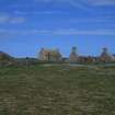
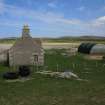
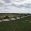
According to the 1st edition of the OS 6-inch map (Inverness-shire – Hebrides 1881, Sheet XXXIII) in 1876 Goular township comprised three substantial roofed buildings. By the end of the 19th century the township had grown and the 2nd edition of the (1904, Sheet XXXIII) shows a cluster of up to eight roofed buildings and associated enclosures. Today, most of those buildings have been removed, though there are surviving two 19th century houses (one unroofed) and another roofless building that may be a blackhouse. There is also the RSPB visitors centre and two roofed sheds.
Visited by RCAHMS (AGCH, IP) 30 May 2012.

