
Balmerino Mill


Grain Mill (18th Century)
Site Name Balmerino Mill
Classification Grain Mill (18th Century)
Alternative Name(s) Corn And Flour Mill
Canmore ID 31761
Site Number NO32SE 30
NGR NO 35752 24920
Datum OSGB36 - NGR
Permalink http://canmore.org.uk/site/31761


- Council Fife
- Parish Balmerino
- Former Region Fife
- Former District North East Fife
- Former County Fife
NO32SE 30.00 35752 24920
NO32SE 30.01 3572 2496 House (Miller's House)
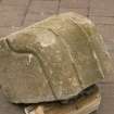
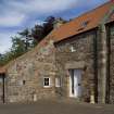
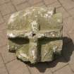
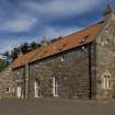
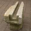
(NO 3574 2492) Balmerino Mill has been gutted and used for farm purposes, and its W end is not original The construction of the deep lintel and chamfers of the doorway on the N front suggest the mill was built in the 17th century and altered since.
NM Record Sheet FR/19/1 (A Graham), 31 August 1968.
The remains of Balmerino Mill are as described by Graham.
Visited by OS (RD) 11 June 1970.
Site recorded by Maritime Fife during the Coastal Assessment Survey for Historic Scotland, Fife Ness to Newburgh 1996
A watching brief was carried out ahead of a proposed new garage build, near to the mill remains in the grounds of the mill house (see NO32SE 30:01). A slope and terrace at the site were thought to be man-made and so were investigated. It may be part of a track that came from the nearby abbey. A trench was excavated across the feature. Glacial sands and gravel and soils were found. A lot of human disturbance was found, perhaps when the terrac ehad been formed. Some mortar was found at the base of the trench and soils near the surface contained some 19th century pottery. This would suggest that the slopes and terrace were fairly recent, perhaps a couple of centuries old or significantly younger. The area had been disturbed significantly by two pipes laid at different times. The terrace may have been part of a mill laid, but this would seem unlikely as no remains were found that would support this. Alternatively it may have been the track bed for the earlier iron pipe which was laid in the area, but subsequently removed. No other archaeological finds were made.
E Proudfoot, 2000
Field Visit (March 2010)
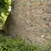
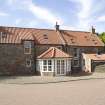
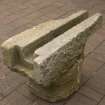
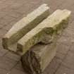
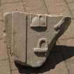
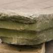
The appearance on the first edition OS 6-inch map of a pair of mill-dams and ponds in the stream gull to the E of the monastic buildings was confirmation that there had been two mills on the unnamed burn that flows past the convent (Fife and Kinross, 1855, sheet 1). Both are documented in a late-16th century rental, where they are described as the Over Mill and the Nether Mill (Campbell 1899, 615-6). The Nether Mill, or Balmerino Mill, now known as the Abbey Mill (NO32SE 30), is of post-medieval date with Abbey stones re-used in its walls. It is an overshot mill with a wheel-pit at its NE end and a square hole for a shaft to be carried into the building in the middle of the wall. The mill building is an L-shaped structure, the long axis aligned from NE to SW that stands to two storeys, with an outshot extending under a sloping roof to the NW of the NE end, reroofed in recent conversion to domestic housing. Built with random rubble, the corners are finished with sandstone quoins and the entrance in the NW wall has chamfered quoins, shallow enough to be of post-medieval date. The window lights are a mixture of small square openings and slit windows with square heads, some clearly made with dressed stone from the Abbey. Two additions have been made to the SW of which one formerly contained a kiln. The mill was fed by a lade that was built up to c2m above the level of the wheel shaft to deliver water, presumably via a trough, now gone, to the top of the wheel. About 38m to the S of the building in the garden of the present house there is a stone lined run-off in the SW side of the terrace of the former lade, which is now used as a path. The course of the lade may be traced as a terrace on the E bank of the burn for about 120m to within a short distance of the stone-built bridge (NO32SE 92) that now carries a road, but was built as a dam and sluice on which a date stone at its foot on the S face indicates that it was built in 1743. The runners for the sides of the sluice can still be seen on the S parapet of the bridge and the small opening for the water at its base, through which the water of the burn now runs. About 100m further up the burn, just beyond the small rectangular sandstone-covered structure, known as the Monk’s Well (NO32SE 2.03), there is a flat-topped bank about 1.2m in thickness that extends some 25m from NW to SE on the NE of which is a 2m wide ditch that runs from a ruptured dam to a subrectangular hollow about 8m across that contains the so-called Monk’s Well, with some stonework visible in the bank on the N side. This is interpreted as the location of the Upper Mill, which in the absence of a pit is interpreted as an undershot or mid-shot mill fed by a lade from the dam to the SE.
Visited by RCAHMS (PJD) March 2010

