
Pitlair


Enclosure (Period Unassigned)
Site Name Pitlair
Classification Enclosure (Period Unassigned)
Canmore ID 31607
Site Number NO31SW 15
NGR NO 31320 11918
Datum OSGB36 - NGR
Permalink http://canmore.org.uk/site/31607


- Council Fife
- Parish Collessie
- Former Region Fife
- Former District North East Fife
- Former County Fife
NO31SW 15 31320 11918
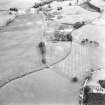
(NO 3131 1192) Enclosure, sub-rectangular, narrow-ditched.
Visible on RCAHMS air photographs F5763-5: flown 1977.
There are no ground surface indications of this enclosure. Its site falls on the edge of a very slight scarp within a low-lying arable field. Inspection of the air photographs shows that this enclosure is sub-oval, measuring approximately 18.0m N-S by 12.0m over a single narrow ditch. There is a possible gap visible in the E side but no other features can be recognised with any certainty.
Visited by OS (B S) 12 September 1978.

