
Pricing Change
New pricing for orders of material from this site will come into place shortly. Charges for supply of digital images, digitisation on demand, prints and licensing will be altered.
South Uist, Hairteabhagh


Fish Trap (Period Unassigned)
Site Name South Uist, Hairteabhagh
Classification Fish Trap (Period Unassigned)
Alternative Name(s) Eilean Dubh, Hairteabhagh
Canmore ID 315845
Site Number NF81NW 9
NGR NF 82904 15391
Datum OSGB36 - NGR
Permalink http://canmore.org.uk/site/315845


- Council Western Isles
- Parish South Uist
- Former Region Western Isles Islands Area
- Former District Western Isles
- Former County Inverness-shire
Field Visit (30 June 2012)
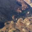
What may be the remains of a fish trap, comprising a boulder spread measuring about 26m in length and 4m in width running N from Eilean Dubh, are visible on aerial photographs taken in 2011 (RCAHMSAP). Unlike other traps in the vicinity (NF81NW 6) that are situated within the intertidal zone, this feature lies below the low tide limit and could not be recorded in detail on the date of visit.
Visited by RCAHMS (GFG) 30 June 2012

