
South Uist, Hartavagh


Fish Trap (Period Unassigned)
Site Name South Uist, Hartavagh
Classification Fish Trap (Period Unassigned)
Alternative Name(s) Eilean Dubh
Canmore ID 315844
Site Number NF81NW 6
NGR NF 8285 1526
Datum OSGB36 - NGR
Permalink http://canmore.org.uk/site/315844


- Council Western Isles
- Parish South Uist
- Former Region Western Isles Islands Area
- Former District Western Isles
- Former County Inverness-shire
Field Visit (30 June 2012)
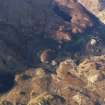
This fish trap, which comprises a broad, arcing spread of boulders measuring up to about 50m in length by 6.6m in thickness and 0.6m in height, spans the narrow channel between the SW shore of Eilean Dubh and the mainland. Visible on aerial photographs taken in 2011 (RCAHMSAP), the trap lies fully exposed at low tide. Given its relatively good condition and its near proximity to a post-medieval settlement (NF81NW 3), it is probable that the two are closely associated.
Beveridge (1911, 323) described how small nets were lodged in a ‘dam formed by small stones’ in North Uist, and it may be that this feature acted in a similar way. Two galvanised steel anchor points, one on each side of the channel, and a pile of netting nearby demonstrates the continuation of fishing here into more recent times.
Visited by RCAHMS (GFG) 30 June 2012.

