
Cornaig Bay


Fish Trap (Period Unassigned)
Site Name Cornaig Bay
Classification Fish Trap (Period Unassigned)
Canmore ID 315820
Site Number NL69NW 143
NGR NL 6320 9680
Datum OSGB36 - NGR
Permalink http://canmore.org.uk/site/315820


- Council Western Isles
- Parish Barra
- Former Region Western Isles Islands Area
- Former District Western Isles
- Former County Inverness-shire
Field Visit (11 October 2011)
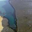
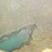
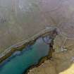
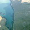
This fish trap, which is situated at the W end of Bagh Chornaig, Vatersay, comprises a wall of rough beach cobbles spread up to 2m in thickness and 0.5m in height, which runs in an arc for a distance of 118m between the N and S shorelines. This wall, now heavily colonised by seaweed, is fully submerged at high tide and becomes exposed on the falling tide. A small gap at its centre is probably the result of erosion by the tidal stream.
The site was visited as part of a the Outer Hebrides Coastal Community and Marine Archaeology Pilot Project (OHCCMAPP), which is a partnership between RCAHMS, WA Coastal and Marine, CNE-Siar and Historic Scotland.
Visited by RCAHMS (AGCH, GG) 11 October 2011.

