Accessibility

Font Size

100% 150% 200%

Background Colour

Default Contrast
Close Reset

Glensanda-meall Na H-easaiche

Quarry (Period Unassigned)

Site Name Glensanda-meall Na H-easaiche

Classification Quarry (Period Unassigned)

Canmore ID 315615

Site Number NM84NW 9

NGR NM 8148 4947

Datum OSGB36 - NGR

Permalink http://canmore.org.uk/site/315615

Ordnance Survey licence number AC0000807262. All rights reserved.
Canmore Disclaimer. © Bluesky International Limited 2025. Public Sector Viewing Terms

Toggle Aerial | View on large map

Digital Images

Oblique aerial view of Glensanda Quarry, looking E.
Oblique aerial view of Glensanda Quarry, looking E.Oblique aerial view of Glensanda Quarry, looking E.Oblique aerial view of Glensanda Quarry, looking ENE.General oblique aerial view of Glensanda-Meall na h-Easaiche and Glensanda quarries, and the remains of Glensanda castle, farmstead and field systems, taken from the SSE.General oblique aerial view of Glensanda-Meall na h-Easaiche and Glensanda quarries, and the remains of Glensanda castle, farmstead and field systems, taken from the SE.Oblique aerial view of Glensanda Quarry, looking NNE.Oblique aerial view of the Glensanda Quarry, looking SW.View across proposed extension to the east of the quarry, facing south east, photograph from an archaeological walkover at Glensanda Quarry, ArdgourView across proposed extension towards the east side of the quarry, facing south west, photograph from an archaeological walkover at Glensanda Quarry, ArdgourView across proposed extension towards the east side of the quarry, facing west, photograph from an archaeological walkover at Glensanda Quarry, ArdgourOblique aerial view of the Glensanda Quarry with Loch Linnhe beyond, looking WSW.View across proposed extension to the east of the quarry, facing north west photograph from an archaeological walkover at Glensanda Quarry, ArdgourView across proposed extension to the north west of the quarry, facing north east, photograph from an archaeological walkover at Glensanda Quarry, ArdgourView across proposed extension to the north west of the quarry, facing south west photograph from an archaeological walkover at Glensanda Quarry, ArdgourAn oblique aerial view of Glensanda Quarry (Meall Na H-easaiche) on the NW shore of Loch Linhe, looking N.Oblique aerial view of Glensanda Quarry, looking NE.View across proposed extension to the east of the quarry, facing east photograph from an archaeological walkover at Glensanda Quarry, ArdgourOblique aerial view of the Glensanda Quarry, looking NW.Oblique aerial view of Glensanda-Meall na h-Easaiche quarry, taken from the WSW.General oblique aerial view of Glensanda-Meall na h-Easaiche and Glensanda quarries, and the remains of Glensanda castle, farmstead and field systems, taken from the SSE.Oblique aerial view of Glensanda Quarry, looking NNE.Oblique aerial view of Glensanda Quarry, looking NNE.Oblique aerial view of Glensanda Quarry, looking NNW.View across proposed extension to the east of the quarry, facing south, photograph from an archaeological walkover at Glensanda Quarry, ArdgourView across proposed extension towards the east side of the quarry, facing west, photograph from an archaeological walkover at Glensanda Quarry, ArdgourView across proposed extension to the south west of the quarry, facing south east, photograph from an archaeological walkover at Glensanda Quarry, ArdgourOblique aerial view of Glensanda-Meall na h-Easaiche and Glensanda quarries, taken from the N.Oblique aerial view of Glensanda-Meall na h-Easaiche quarry, taken from the SSW.General oblique aerial view of Glensanda-Meall na h-Easaiche and Glensanda quarries, and the remains of Glensanda castle, farmstead and field systems, taken from the SSE.View across proposed extension to the south west of the quarry, facing east, photograph from an archaeological walkover at Glensanda Quarry, Ardgour

Administrative Areas

  • Council Highland
  • Parish Ardgour
  • Former Region Highland
  • Former District Lochaber
  • Former County Argyll

Activities

Field Walking (11 July 2011 - 20 October 2011)

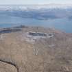
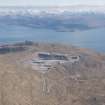
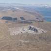
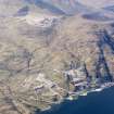
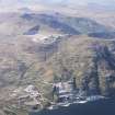
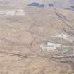
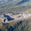
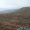
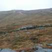
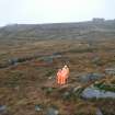
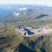
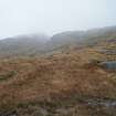
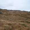
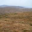
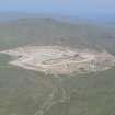
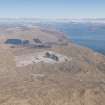
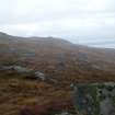
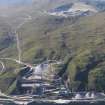
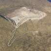
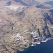
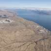
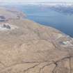
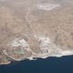
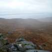
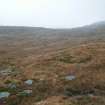
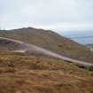
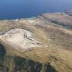
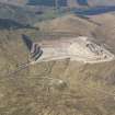
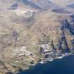
Headland Archaeology Ltd carried out an archaeological walkover of an area of some 138 hectares around Glensanda Quarry. The quarry is situated at 400 to 600 m above the north-western shore of Loch Linnie some 20km to the north of Oban. The area aff ected by the extension comprised mainly steep and rocky terrain covered in tussocky grass. The area was very exposed with little shelter from the elements. No features of archaeological interest were identified.

Aerial Photography (1 May 2011)

Field Visit (24 November 2011)

NM 81500 49500 A walkover survey was carried out on 24 November 2011 of a c138ha area around Glensanda Quarry prior to its extension. The quarry is 400–600m above the NW shore of Loch Linnie and the surveyed area consisted of steep and rocky grass covered terrain. There were no finds or features of archaeological significance.

Archive: RCAHMS

Funder: Aggregate Industries

Magnar Dalland, Headland Archaeology Ltd

2012

Field Visit (24 November 2011)

Headland Archaeology Ltd carried out an archaeological walkover of areas around Glensanda Quarry. No features of archaeological interest were identified.

Information from OASIS ID: headland1-117110 (M Dalland) 2011

References

MyCanmore Image Contributions


Contribute an Image

MyCanmore Text Contributions