
Cupar, Tolbooth


Tolbooth (Medieval)
Site Name Cupar, Tolbooth
Classification Tolbooth (Medieval)
Canmore ID 31497
Site Number NO31SE 17
NGR NO 3753 1456
Datum OSGB36 - NGR
Permalink http://canmore.org.uk/site/31497


- Council Fife
- Parish Cupar
- Former Region Fife
- Former District North East Fife
- Former County Fife
NO31SE 17 3753 1456.
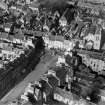
(NO 3734 1456) "The old Tolbooth of Cupar stood at the Cross, midway between the entrances to Bonnygait (sic) and St. Catherine Street." A pictorial plan of Cupar by Gordon of Rothiemay, 1642, is reporduced showing the "Tollbuith". (It seems to haveoccupied very nearly the site of the modern Town Hall, projecting rather more to the west across the entrance to the Crossgate.)
A H Millar 1895.
The siting derived from the above information is at NO 3753 1456. No vestige of the tolbooth exists.
Visited by OS (R D L) 21 May 1964.
Publication Account (1971)
The tolbooth of Cupar was first mentioned in 1441. For centuries it stood at the Cross between the entrance to Bonnygate and St. Catherine Street (Lamb., 1885, i , 129). When the latter street was opened up in 1817 the tolbooth was removed and a new town hall and county offices were erected nearby (Lamb, 1885, i, 129).
Information from ‘Historic Cupar: The Archaeological Implications of Development’ (1981).

