Accessibility

Font Size

100% 150% 200%

Background Colour

Default Contrast
Close Reset

Ferntown Hill

Palisaded Settlement (Period Unassigned)

Site Name Ferntown Hill

Classification Palisaded Settlement (Period Unassigned)

Canmore ID 313595

Site Number NX05NE 83

NGR NX 05674 56792

Datum OSGB36 - NGR

Permalink http://canmore.org.uk/site/313595

Ordnance Survey licence number AC0000807262. All rights reserved.
Canmore Disclaimer. © Bluesky International Limited 2025. Public Sector Viewing Terms

Toggle Aerial | View on large map

Digital Images

Oblique aerial view of the cropmarks of the palisaded settlement, taken from the N.
Oblique aerial view of the cropmarks of the palisaded settlement, taken from the N.Oblique aerial view of the cropmarks of the palisaded enclosure, taken from the SE.Oblique aerial view of the cropmarks of the palisaded enclosure, taken from the ENE.Oblique aerial view of the cropmarks of the palisaded enclosure, taken from the NNW.Oblique aerial view of the cropmarks of the palisaded settlement, looking NNE.Oblique aerial view of the cropmarks of the palisaded settlement, taken from the NW.Oblique aerial view of the cropmarks of the palisaded settlement, taken from the SSE.Oblique aerial view of the cropmarks of the palisaded settlement, taken from the SSW.Oblique aerial view of the cropmarks of the palisaded settlement, looking NE.Oblique aerial view of the cropmarks of the palisaded enclosure, taken from the SSW.Oblique aerial view of the cropmarks of the palisaded settlement, taken from the SW.Oblique aerial view of the cropmarks of the palisaded enclosure, taken from the NE.Oblique aerial view of the cropmarks of the palisaded enclosure, taken from the SW.

Administrative Areas

  • Council Dumfries And Galloway
  • Parish Portpatrick
  • Former Region Dumfries And Galloway
  • Former District Wigtown
  • Former County Wigtownshire

Archaeology Notes

NX05NE 83 05674 56792

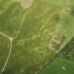
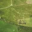
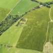
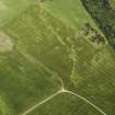
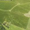
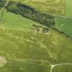
This palisaded enclosure has been recorded as a cropmark on oblique aerial photographs (RCAHMSAP 2009). It is curvilinear in plan and defined by a narrow palisaded ditch about 1.2m wide. The enclosed area is 43.4m in diameter, and there are 3 breaks in the E section of the palisade where there may have been entrances.

Information from RCAHMS (KHJM) 15 Nov 2011

Activities

Aerial Photography (2 August 2009)

Aerial Photographic Transcription (15 November 2011)

References

MyCanmore Image Contributions


Contribute an Image

MyCanmore Text Contributions