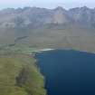
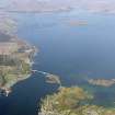
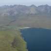
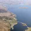
Accessibility

Font Size

100% 150% 200%

Background Colour

Default Contrast
Close Reset

Cuillin Hills

General View (Period Unassigned)

Site Name Cuillin Hills

Classification General View (Period Unassigned)

Canmore ID 313419

Site Number NG42SW 16

NGR NG 4495 2080

Datum OSGB36 - NGR

Permalink http://canmore.org.uk/site/313419

Ordnance Survey licence number AC0000807262. All rights reserved.
Canmore Disclaimer. © Bluesky International Limited 2025. Public Sector Viewing Terms

Toggle Aerial | View on large map

Digital Images

General oblique aerial view of Glenbrittle with the Cuillin Hills beyond, taken from the WSW.
General oblique aerial view of Glenbrittle with the Cuillin Hills beyond, taken from the WSW.General oblique aerial view of the Skye Bridge with Kyle of Lochalsh in the foreground and the Cuillin Hills in the distance, taken from the S.General oblique aerial view of Applecross Bay with Skye in the distance, looking WSW.Oblique aerial view of Ben Dearg with Portree and the Cullins beyond.General oblique aerial view of the Cuillin Hills with Gars-bheinn in the foreground, taken from the SSE.General oblique aerial view looking into the Cuillin Hills over Loch na Creitheach, with Blabheinn to the right, taken from the S.General oblique aerial view looking over Glen Scaladal with Beinn na Caillich and Torrin beyond, taken from the WSW.General oblique aerial view of the Cuillin Hills, Skye, looking WNW.General oblique aerial view of the Cuillin Hills, Skye, looking WNW.General oblique aerial view of the Cuillin Hills, Skye, looking WNW.General oblique aerial view of the Cullin Hills with Rum and Canna beyond, looking SW.Oblique aerial view of Loch Eynort with the Cullins beyond.General oblique aerial view of the Cuillin Hills with Gars-bheinn in the foreground, taken from the SSE.General oblique aerial view of the Cullin Hills, Skye, looking NNE.General oblique aerial view of Loch Sligachan and the Cuillin Hills, looking SW.General oblique aerial view of the Cuillin Hills, Skye, looking W.General view of mountains.
Titled 'Blaven, Skye, 609 J.V.'
PHOTOGRAPH ALBUM No.33: COURTAULD ALBUM.General oblique aerial view of the Cullin Hills with Rum and Canna beyond, looking SW.Oblique aerial view.General oblique aerial view of Glenbrittle with the Cuillin Hills beyond, taken from the WSW.General oblique aerial view of the Cuillin Hills centred on Loch Coir' a' Ghrunnda, taken from the S.View of landscape. 
Titled: 'Hart o'Corry, Cuchullin Hills, Skye, 508 J.V.'
PHOTOGRAPH ALBUM No.33: COURTAULD ALBUM.General oblique aerial view of Blabheinn with the Cullin Hills, Loch Scavaig, Soay, Eigg, Rum and Canna beyond, looking SSW.General oblique aerial view looking into the Cuillin Hills over Loch Coruish, with Sgurr nan Gillean to the right, taken from the S.General oblique aerial view of the Cullin Hills with Kirkibost and Blabheinn in the foreground, looking WNW.General oblique aerial view of the Cuillin Hills with Gars-bheinn in the foreground, taken from the SSE.General oblique aerial view of the Skye Bridge and the Cuillin Hills in the distance, taken from the S.View of landscape.
Titled: 'Glen Sligichan, and Mar Cow, Skye, 1049, J.V.'General oblique aerial view of the Cullin Hills with Kirkibost and Blabheinn in the foreground, looking WNW.Oblique aerial view of Ben Dearg with Portree and the Cullins beyond.General oblique aerial view looking across Beinn na Caillich and Blabheinn towards the Cuillins, taken from the NE.General oblique aerial view of the Cuillin Hills with Gars-bheinn in the foreground, taken from the SSE.General oblique aerial view across Broadford towards Beinn na Caillich, looking WNW.General oblique aerial view of the Cuillin Hills, Skye, looking W.General oblique aerial view of Blabheinn with the Cullin Hills beyond, looking WSW.General oblique aerial view of Blabheinn with the Cullin Hills, Loch Scavaig, Soay, Rum and Canna beyond, looking SSW.Oblique aerial view.General oblique aerial view across Broadford towards Beinn na Caillich, looking WNW.General oblique aerial view looking across Beinn na Caillich and Blabheinn towards the Cuillins, taken from the NE.General oblique aerial view looking along Loch Eynort towards the Cuillin Hills, taken from the W.General oblique aerial view of the Cuillin Hills with Gars-bheinn in the foreground, taken from the SSE.General oblique aerial view looking into the Cuillin Hills over Loch Coruish, with Sgurr nan Gillean to the right, taken from the S.General oblique aerial view of the wind farm at Edinbane and the Waternish peninsula, looking toward the Cuillin hills, Skye, taken from the SW.General oblique aerial view of Soay with the Cuillin Hills beyond, taken from the S.General oblique aerial view of Loch Sligachan and the Cuillin Hills, looking SW.General oblique aerial view with Sleat in the foreground and Loch Eishort and the Cullins beyond, looking WNW.General oblique aerial view of the Cuillin Hills, Skye, looking W.General oblique aerial view of Broadford and the Cuillin Hills, Skye, looking W.Oblique aerial view.

Administrative Areas

  • Council Highland
  • Parish Bracadale
  • Former Region Highland
  • Former District Skye And Lochalsh
  • Former County Inverness-shire

Activities

Aerial Photography (31 May 2009)

References

MyCanmore Image Contributions


Contribute an Image

MyCanmore Text Contributions