
Leips


Farmstead (18th Century)
Site Name Leips
Classification Farmstead (18th Century)
Alternative Name(s) Leipes; Lypis; Lippes; Leippis; Leeps
Canmore ID 313141
Site Number NT26NW 504
NGR NT 2354 6548
Datum OSGB36 - NGR
Permalink http://canmore.org.uk/site/313141


- Council Midlothian
- Parish Lasswade
- Former Region Lothian
- Former District Midlothian
- Former County Midlothian
Field Visit (5 May 1983 - 5 May 1983)
Midlothian Field Group site visit and sketch.
Field Visit (26 September 2010 - 26 September 2010)
Field walking with SRP Pentlands and EAFS members to relocate the site, 26 September 2010; second site visit, 2 May 2011; historical research in the NAS, June 2010 - May 2011.
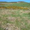
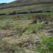
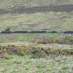
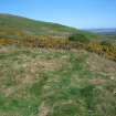
Leips farmstead lies in the Boghall Burn valley in a field known today as “Leips field”. It is sited on a dry promontory above boggy ground on the N bank of the burn 900m NW of Boghall Farm (NT2440 6510) and about 100m S of the public track to Allermuir Hill. The site comprises the grass covered footings of one or possibly two buildings lying within a tripartite elongated boat-shaped enclosure. It is heavily overgrown with gorse and bracken making identification and interpretation of the remains very difficult, but the distinctive enclosure is clearly identifiable on aerial photographs (see for example, Google maps http://maps.google.co.uk/maps?t=h&hl=en-GB&ie=UTF8&ll=55.876484,-3.222857&spn=0.001351,0.005262&z=18).
The boat-shaped enclosure lies on an E-W alignment and consists of a central rectangular enclosure, measuring c35m x c30m within walls 1m wide which stand up to 1m high, flanked on the E and W by two flat ended triangular enclosures, each measuring approximately 25m x 30m. The E enclosure shows signs of lazy-bed cultivation and was probably a garden plot. A rectangular building, probably a barn, lies within the central enclosure on a N – S alignment, sharing its E wall with the E wall of the enclosure. It measures 20m x 7m within walls 1m thick and has opposed entrances centrally placed in the E and W walls, and a third entrance in the top half of the W wall. A short length of wall extending at right angles from the N end of the W wall may be the remains of a second building, but the density of vegetation makes it impossible to say with certainty.
The E enclosure terminates at the edge of a gully and there are possible traces of a trackway leading down Boghall Burn to Boghall farmhouse. To the S, the site looks towards the N face of Woodhouselee Hill which is covered by rig and furrow (probably belonging to the Woodhhall Estate) of at least two different periods stretching right down to the S bank of Boghall Burn.
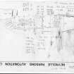
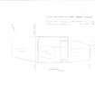
The site was visited and sketched by the Midlothian Studies Group in 1983 (Geoff Waters) and in September 2010 it was revisited by SRP Pentland Hills and a geo-referenced site sketch made using a handheld GPS (Don Matthews). Both of these surveys are attached to this site record and they form the basis of a more detailed measured sketch which was drawn at 1:500 in May 2011. The principal changes observed since 1983 have occurred in the W enclosure which is bisected from the rest of the site by a modern fence and now lies within an improved pasture field; here the N wall appears reduced and traces of lazy beds identified in 1983 could not be seen.
Leips (or Leippis) is mentioned in charters from 1542 onwards and is depicted on Timothy Pont’s map, ‘A new description of the Shyres of Lothian and Linlitquo’ in 1630 and on Blaeu’s 1654 map of ‘Lothian and Linlitquo.’ In 1688 the “Roume called Boighall then possest be John Abernethie and now be George Aitken that other Roume called the Leips then possest be William Johnstoun and now be the tenants of Paintland in Common” were given in life rent to the wife of Sir Alexander Gibson (NAS SIG1/65/21). Although Leips lay outside the Commonty division of 1709, depositions by tenants who had been herdsmen at Leips (NAS GD89/1/860) reveal that its grazing rights encompassed much of the hilltop areas of Hillend, perhaps extending as far as Caerketton Crags and its boundary was contiguous with that of Swanston.
In 1746 James Pennycook and his daughter occupied Leips probably as sub tenants of John Grinton of Boghall who in 1748 was given the tenancy of Boghall and Leips for 21 years (NAS RD3/211/2 f379). These lands were already possessed by Grinton and since there is no separate tenancy for Pennycook his association with Leips must have been through Grinton. This tenancy also mentions that the houses and offices upon these lands had been new built so it would appear that a new set of buildings had been constructed for an existing farm holding at Boghall and these improvements may also have included Leips. Indeed, in 1741 the proprietor of the Pentland estate, Sir Alexander Gibson had written to Sir John Clerk of the neighbouring Penicuik estate to ask if he could make use of Clerk’s quarry at Paradykes to win stone for his “new farms at Pentland” since he was pushed to find any of his own (NAS GD18/5731).
Leips is not shown on William Roy’s Military Survey of Scotland, 1747-55, and although “Leips Hill” is depicted on John Laurie’s ‘A plan of the county of Mid-Lothian’ (1763), no dwelling is shown. However Leeps is depicted on Andrew and Mostyn Armstrong’s ‘Map of the three Lothians’ (1773), and also on James Knox’s ‘Map of the Shire of Edinburgh’ (1812), Robert Kirkwood’s ‘A Map of the environs of Edinburgh’ (1817), and John Thomson’s ‘Edinburgh-shire’ (1821), where it is shown considerably higher up the hill and may have moved from the valley floor to a hill-slope terrace. This appears to correspond with a rectangular feature on the present Ordnance Survey map (NT 23678 65694) where field walking identified an enclosure bank alongside an area densely covered by whin bushes. Leips must have fallen out of use soon after that date because it does not appear in the 1841 census and is not shown on the 1st Edition Ordnance Survey map. Will Grant in “Pentland Days and Country Ways” [1934] p.89 describes the site as consisting of only a few juniper bushes and nettles.
As a further historical note John Grinton of Boghall, James Pennycook of Leips and Alison his daughter have left far more records than just tenancy charters because two years after gaining his new 1748 tenancy John Grinton was in trouble. Documents (NAS CS271/58185) reveal that John Grinton and Alison Pennycook had frequent meetings in her father’s barn and in 1747 they had a son who was christened at Lasswade. Alison claimed John Grinton had promised marriage, she made wedding clothes for them both and although no formal ceremony had taken place, she considered they were married. So in 1750 when he married another woman, Ann Grate, daughter of his herdman, she brought a legal case against him. Although John Grinton makes it clear that he never considered he was married to Alison, the case was decided against him in 1752 and he was required to pay a large sum in Damages which “not only made a great Noise but wronged much John Grinton’s Credit”. His new wife petitioned him for divorce (NAS CC8/6/348) and because he was by then two years in arrears with his rent (£180 sterling) the proprietor, Sir Alexander Gibson issued a removal notice against him. The resulting legal papers (NAS CS271/66964) reveal that faced with the prospect of losing everything, Grinton made an arrangement with his neighbour James Gibson for the latter to take over his tenancy and rent while John Grinton would become a sub-tenant. The proprietor therefore wrote a new tenancy for James Gibson but a few days later discovered that Grinton had sold all his sheep to another farmer “thereby rendering [James Gibson’s] possession of the Sheep Room of Leeps hill useless for want of sheep”. The removal order against Grinton was therefore reissued and probably carried out. Finally a gravestone in Old Pentland churchyard records the death of James Pennycook who died at Pentland in 1761 aged 83 as a “Tenant in Leaps” and also, sadly, that of the young James Grinton who died age 5.
Information from SRP Pentland Hills, September 2011.

