
Pricing Change
New pricing for orders of material from this site will come into place shortly. Charges for supply of digital images, digitisation on demand, prints and licensing will be altered.
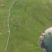
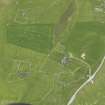
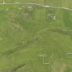
Unst, Kirkamires


Farmstead (Period Unassigned)
Site Name Unst, Kirkamires
Classification Farmstead (Period Unassigned)
Canmore ID 313115
Site Number HP50SE 124
NGR HP 5747 0417
Datum OSGB36 - NGR
Permalink http://canmore.org.uk/site/313115


- Council Shetland Islands
- Parish Unst
- Former Region Shetland Islands Area
- Former District Shetland
- Former County Shetland
Field Visit (January 1970 - December 1991)
A survey of deserted settlements in Unst by June Owers. The survey includes photographs, sketches and historical information.
Note (26 September 2011)
A plan of this farmstead was drawn by June Owers in her survey of deserted settlements in Unst (1970). It depicts a farmstead comprising a former croft house aligned NW-SE with a range of two buildings set parallel to the dwelling on its SW side. A yard is connected to the farmstead on its SE side.
A farmstead comprising one roofed T-shaped building of three compartments, and one enclosure is depicted on the 1st edition of the OS 6-inch map (Orkney and Shetland (Shetland) 1882, sheet viii). A well is depicted to the W of the farmstead.
Information from RCAHMS (BRW) 26 September 2011

