Accessibility

Font Size

100% 150% 200%

Background Colour

Default Contrast
Close Reset

Bo'ness, Bridgeness And Carriden Area Of Townscape Character

Town Quarter (Period Unassigned)

Site Name Bo'ness, Bridgeness And Carriden Area Of Townscape Character

Classification Town Quarter (Period Unassigned)

Canmore ID 312676

Site Number NT08SW 169

NGR NT 01420 81333

Datum OSGB36 - NGR

Permalink http://canmore.org.uk/site/312676

Ordnance Survey licence number AC0000807262. All rights reserved.
Canmore Disclaimer. © Bluesky International Limited 2025. Public Sector Viewing Terms

Toggle Aerial | View on large map

Digital Images

Street view showing 14-28 Cuffabouts, Bo'ness, taken from the North-West. This photograph was taken as part of the Bo'ness Urban Survey to illustrate the character of Bridgeness and Carriden Area of Townscape Character.
Street view showing 14-28 Cuffabouts, Bo'ness, taken from the North-West. This photograph was taken as part of the Bo'ness Urban Survey to illustrate the character of Bridgeness and Carriden Area of Townscape Character.Street view showing 1-7 Cuffabouts, Bo'ness, taken from the South-East with Foredale Terrace in the background. This photograph was taken as part of the Bo'ness Urban Survey to illustrate the character of Bridgeness and Carriden Area of Townscape Character.View of The Tower Gardens, Bo'ness, taken from the South-East looking towards Bridgeness Tower. This photograph was taken as part of the Bo'ness Urban Survey to illustrate the character of Bridgeness and Carriden Area of Townscape Character.View of terraced housing at 50-60 Philpingstone Road, Bo'ness, taken from the North-West. This photograph was taken as part of the Bo'ness Urban Survey to illustrate the character of Bridgeness and Carriden Area of Townscape Character.Street view showing housing at 12a-24 Craigfoot Terrace, Bridgeness Road, Bo'ness, taken from the North-West. This photograph was taken as part of the Bo'ness Urban Survey to illustrate the character of Bridgeness and Carriden Area of Townscape Character.View of Carriden Old Church, Carriden Brae, Bo'ness, taken from the North-West. This photograph was taken as part of the Bo'ness Urban Survey to illustrate the character of Bridgeness and Carriden Area of Townscape Character.View of Carriden Old Church, Carriden Brae, Bo'ness, taken from the South-East. This photograph was taken as part of the Bo'ness Urban Survey to illustrate the character of Bridgeness and Carriden Area of Townscape Character.Street view showing 1-11 Cuffabouts, Bo'ness, taken from the South-East with Foredale Terrace in the background. This photograph was taken as part of the Bo'ness Urban Survey to illustrate the character of Bridgeness and Carriden Area of Townscape Character.Street view showing 45 and 47 Philpingstone Road, Bo'ness, in the foreground with rows of terraced housing on Philpingstone Lane receding in the background. This photograph was taken as part of the Bo'ness Urban Survey to illustrate the character of Bridgeness and Carriden Area of Townscape Character.Street view showing the West side of Cowdenhill Road, Bo'ness, taken from the North-East. The image shows the Mission Hall at No 14 and detached and semi-detached housing at Nos 16-32 behind. This photograph was taken as part of the Bo'ness Urban Survey to illustrate the character of Bridgeness and Carriden Area of Townscape Character.View of Carriden Parish Church, Carriden Brae, Bo'ness, taken from the West. This photograph was taken as part of the Bo'ness Urban Survey to illustrate the character of Bridgeness and Carriden Area of Townscape Character.View of Carriden Old Church, Carriden Brae, Bo'ness, taken from the South-East. This photograph was taken as part of the Bo'ness Urban Survey to illustrate the character of Bridgeness and Carriden Area of Townscape Character.View of The Tower Gardens, Bo'ness, taken from the North-East looking towards Bridgeness Tower. This photograph was taken as part of the Bo'ness Urban Survey to illustrate the character of Bridgeness and Carriden Area of Townscape Character.View showing four-in-a-block housing at 1-3 Harbour Road and 116-118 Bridgeness Road, Bo'ness, taken from the South-West. Victoria Mills Industrial Estate and 119 Bridgeness Road are visible in the background. This photograph was taken as part of the Bo'ness Urban Survey to illustrate the character of Bridgeness and Carriden Area of Townscape Character.View of housing at 1-31 South Philpingstone Lane, Bo'ness, taken from the South-West. This photograph was taken as part of the Bo'ness Urban Survey to illustrate the character of Bridgeness and Carriden Area of Townscape Character.View of Carriden Old Church, Carriden Brae, Bo'ness, taken from the West. This photograph was taken as part of the Bo'ness Urban Survey to illustrate the character of Bridgeness and Carriden Area of Townscape Character.Street view of Philpingstone Road, Bo'ness, taken from the East at the junction with South Philpingstone Lane. This photograph was taken as part of the Bo'ness Urban Survey to illustrate the character of Bridgeness and Carriden Area of Townscape Character.View of terraced housing at 50-60 Philpingstone Road, Bo'ness, taken from the South-West with No 50 in the foreground. This photograph was taken as part of the Bo'ness Urban Survey to illustrate the character of Bridgeness and Carriden Area of Townscape Character.View of Carriden Old Church, Carriden Brae, Bo'ness, taken from the South-East. This photograph was taken as part of the Bo'ness Urban Survey to illustrate the character of Bridgeness and Carriden Area of Townscape Character.Street view of Birdland Avenue looking North towards Bridgeness Road. This photograph was taken as part of the Bo'ness Urban Survey to illustrate the character of Bridgeness and Carriden Area of Townscape Character.Street view showing 6-22 South Philpingstone Lane, Bo'ness. This photograph was taken as part of the Bo'ness Urban Survey to illustrate the character of Bridgeness and Carriden Area of Townscape Character.View of Carriden Old Church, Carriden Brae, Bo'ness, taken from the West. This photograph was taken as part of the Bo'ness Urban Survey to illustrate the character of Bridgeness and Carriden Area of Townscape Character.Street view of modern housing at Kirk Place, Bo'ness, taken from the North-East. This photograph was taken as part of the Bo'ness Urban Survey to illustrate the character of Bridgeness and Carriden Area of Townscape Character.Street view showing 1-17 Foreshore Way, Bo'ness, taken from the North-East. This photograph was taken as part of the Bo'ness Urban Survey to illustrate the character of Bridgeness and Carriden Area of Townscape Character.View of The Tower Gardens, Bo'ness, taken from the North-East looking towards Bridgeness Tower. This photograph was taken as part of the Bo'ness Urban Survey to illustrate the character of Bridgeness and Carriden Area of Townscape Character.Street view showing corner block of flats at 2-4 Harbour Road, 108 Bridgeness Road and 112-114 Philpingstone Road, Bo'ness, taken from the North-East. This photograph was taken as part of the Bo'ness Urban Survey to illustrate the character of Bridgeness and Carriden Area of Townscape Character.Street view of Philpingstone Road, Bo'ness, taken from the North-East at the junction with South Philpingstone Lane and Philpingstone Lane. This photograph was taken as part of the Bo'ness Urban Survey to illustrate the character of Bridgeness and Carriden Area of Townscape Character.Street view showing the West side of Cowdenhill Road, Bo'ness, taken from the North-East. The image shows the Mission Hall at No 14 and terraced housing at Nos 8-12 Cowdenhill Road. This photograph was taken as part of the Bo'ness Urban Survey to illustrate the character of Bridgeness and Carriden Area of Townscape Character.Street view showing housing at 12a-24 Craigfoot Terrace, Bridgeness Road, Bo'ness, taken from the North-East. This photograph was taken as part of the Bo'ness Urban Survey to illustrate the character of Bridgeness and Carriden Area of Townscape Character.View of Carriden Old Church and Churchyard, Carriden Brae, Bo'ness, taken from the East. This photograph was taken as part of the Bo'ness Urban Survey to illustrate the character of Bridgeness and Carriden Area of Townscape Character.General street view showing 1-27 Foredale Terrace, Bo'ness, taken from the South-East. This photograph was taken as part of the Bo'ness Urban Survey to illustrate the character of Bridgeness and Carriden Area of Townscape Character.Street view looking South along Foredale Terrace from the junction with Bridgeness Road. Alexander and Garden Cottages can be seen to the left of the shot. This photograph was taken as part of the Bo'ness Urban Survey to illustrate the character of Bridgeness and Carriden Area of Townscape Character.Street view showing South Philpingstone Lane, Bo'ness, taken from the East. Nos 16-22 are in the foreground with 6-14 in the centre and 1-7 to the right of the shot. This photograph was taken as part of the Bo'ness Urban Survey to illustrate the character of Bridgeness and Carriden Area of Townscape Character.General view showing the rear of 48 and 50 Philpingstone Road, Bo'ness, taken from the South-East from South Philpingstone Lane. Terraced housing on Philpingstone Lane is visible in the background of the image. This photograph was taken as part of the Bo'ness Urban Survey to illustrate the character of Bridgeness and Carriden Area of Townscape Character.View of terraced housing at 50-60 Philpingstone Road, Bo'ness, taken from the North-West. This photograph was taken as part of the Bo'ness Urban Survey to illustrate the character of Bridgeness and Carriden Area of Townscape Character.View of the Mission Hall at 14 Cowdenhill Road, Bo'ness, taken from the East. This photograph was taken as part of the Bo'ness Urban Survey to illustrate the character of Bridgeness and Carriden Area of Townscape Character.Street view of Bridgeness Road, Bo'ness, taken from the North-West with No 40 in the foreground. This photograph was taken as part of the Bo'ness Urban Survey to illustrate the character of Bridgeness and Carriden Area of Townscape Character.

Administrative Areas

  • Council Falkirk
  • Parish Bo'ness And Carriden
  • Former Region Central
  • Former District Falkirk
  • Former County West Lothian

Activities

Characterisation (19 November 2013)

This site covers the Bridgeness and Carriden Area of Townscape Character which was defined as part of the Bo'ness Urban Survey Project 2013. The text below relates to the whole area.

Historical Development and Topography

The Bridgeness and Carriden area is located on the lower slopes of the north-facing hill to the south of Bridgeness Road. The area to the north fronting the River Forth has been designated as an industrial area although part of the historic area of Bridgeness. Carriden lies to the east of the area with Kiningars Park forming the southern part of the area.

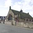
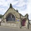
The ruins of Carriden Old Church (1766), at the eastern end of the area, appear to be all that survives of the early settlement of Carriden which grew up in relation to Carriden House (1602) to the south-east outwith the urban area of Bo’ness. A larger church designed by Peter Macgregor Chalmers (1859-1922) was built in 1908-9 north of the Old Church to accommodate a growing congregation. Carriden now consists of a large interwar social housing development of harled, two-storeyed, semi-detached houses in a garden city-inspired layout, now also incorporating late 20th century red brick bungalows and two-storeyed detached houses. A small group of villas front onto Bridgeness Road and on the corner with Carriden Brae is a small late 20th century executive home development, Carriden Glade.

The area of Grange is incorporated within this character area as part of Bridgeness. Its most prominent landmark is Bridgeness Tower in The Tower Gardens. Dated 1750, it was originally a windmill which was converted into an observatory in 1895 by Hippolyte Blanc (1844-1917) before subsequently being restored as a house in 1989 by William Archibald Caddell Architects who also designed the Saltire Award winning harled housing that surrounds it. To the east lies Grange House, the 19th century home of the Caddells of Grange. Now a nursing home, it is hidden from Bridgeness Road and Bridgeness Lane by 20th century housing, though it opens into the extensive green space of Kinningars Park. A late 17th century lectern dovecot stands in the Park. This was built for an earlier Grange House (1564, demolished 1906) which stood near the site of Grange School on Grange Loan (Braehead and The Knowe Area of Townscape Character).

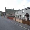
The late Victorian Craigfoot Terrace is the most important 19th century urban housing in the area along with Philpingstone Road (Gladstone Terrace and Coronation Cottages). The western third of the area is characterised by another area of interwar social housing at Fountainpark Crescent.

There has been much infilling and redevelopment of plots during the late 20th and early 21st century, particularly in Philpingstone Road and Lane to the west of the area, and a large area on the south side of Bridgeness Road (Birdland Avenue, Kinacres Grove and Foredale Terrace).

Present Character

The ruin of the Old Church at Carriden and the 17th century dovecot in Kinningars Park are the earliest survivors of the area’s origins. The area is mostly residential and has developed in a series of cul-de-sacs leading off the principal roads through the area, Bridgeness Road and Philpingstone Road.

While the north side of Bridgeness Road developed as Bridgeness Colliery on reclaimed land during the 19th century, very little expansion took place on the south side of the road at that time. There are a few pockets of 19th century cottages along Bridgeness Road and Philpingstone Road. As the colliery expanded, housing was built nearby for workers, including the two-storeyed, half-timbered terrace of flats at Craigfoot Terrace, built in 1890 to designs by James Thomson (b.1867) on behalf of the mine owner Henry Moubray Cadell (1860-1934).

The area was infilled at different periods during the 20th century, with model housing at Coronation Cottages (1902) and Gladstone Terrace (1905) on Philpingstone Road continuing the housing provision for the growing number of industrial workers. Surrounding these are larger developments dating from the mid- to late 19th century. In Fountainpark Crescent, a cluster of two-storeyed, gabled, four-in-a-block local authority housing dates from c.1950 and is laid out in a garden city style, typical of the social housing being built during this period.

Later 20th century and early 21st century developments in both the Philpingstone Road area and stretching along Bridgeness Road to Cuffabouts/Carriden have joined Bridgeness and Carriden into the urban area of Bo’ness. The most recent developments of Bridgeness Road consist of large three-storeyed blocks of flats leading into Birdland Avenue, Foreshore Way and Kirk Place, all with red brick and harled, detached, semi-detached and terraced private housing.

The large open space of Kinningars Park gives the area a more open feel than the density of the housing developments would suggest.

Information from RCAHMS (LK), 19th November 2013

References

MyCanmore Image Contributions


Contribute an Image

MyCanmore Text Contributions